Walk 1703 - printer friendly version
Longdendale from Hadfield Station Walk
Author - Jake Robertson
Length - 9.0 miles / 14.6 km
Ascent - 1000 feet / 303 metres
Grade - easy/mod
Start - OS grid reference SK024960
Lat 53.460743 + Long -1.9653205
Postcode SK13 1AH (approx. location only)
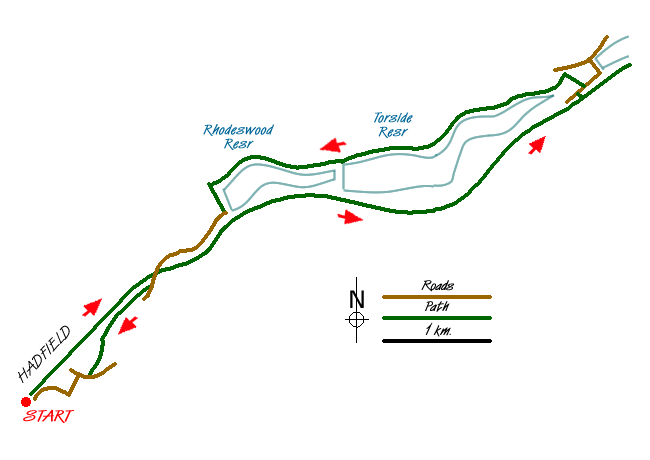
This is a gentle low-level Peak District walk up the deep Longdendale valley along the route of the old Woodhead railway and returning along reservoir paths under the brooding slopes of Bleaklow and Black Hill. The start is at Hadfield station (grid ref. SK024960), which is served by half-hourly trains from Manchester Piccadilly, alternatively there is car parking by the Longdendale Trail (grid ref. SK024961).
Leave Hadfield station and go right onto Platt Street and when the road swings under a bridge go left into the car park and join the Longdendale Trail. From here it is a simple matter of following the trail up the valley all the way to where it meets the road by the Woodhead Dam. It's an easy stroll with the views growing ever more wild and impressive as you head up the valley, the section from the Pennine Way crossing to Pasture Wood beneath Torside and Wildboar Cloughs is particularly spectacular.
At the Woodhead Dam leave the trail and go right down the road for a short distance then cross it and take a signed concessionary footpath down through the wood. It crosses a weir beneath the dam then turns east by the shore of Torside Reservoir for about 1 ½ miles, meeting the Pennine Way for a short section to Torside Dam. Along the way there is a turn off to Crowden, just over the road where refreshments may be bought at the campsite.
Instead of following the Pennine Way over the dam wall take the lower of two tracks on the northern side of Rhodeswood Reservoir for lovely quiet section with Bramah Edge and the Devil's Elbow looming above on the opposite side. Eventually the dam is reached and you should cross it and soon the track becomes a tarmac lane by Deepclough. Follow this lane until it crosses over the Longdendale Trail then immediately take a signposted footpath on the right, passing through fields with superb views of Hadfield, Hollingworthhall Moor and back up the valley. It turns into a walled lane to emerge between houses at Padfield.
Go right then take the second left onto Post Street to a t-junction then go right again on Platt Street which leads downhill back under the Longdendale Trail to the railway station.
Messaging & Social Media
Message Walking Britain and follow the latest news.

Mountain Weather
Stay safe on the mountains with detailed weather forecasts - for iOS devices or for Android devices.