Hartshill Country Park near Nuneaton
Warwickshire Walk
County/Area - Warwickshire
Author - David McMahon
Length - 2.0 miles / 3.3 km Ascent - 330 feet / 100 metres
Time - 1 hours 20 minutes Grade - easy
Walk Route Description
Click image to see photo description.
This Warwickshire circular walk explores the Hartshill Country Park, which lies to the West of the Hartshill village a few miles north of Nuneaton. Hartshill can be reached by Stagecoach route 48 with a change at Nuneaton if travelling from Leicester or Coventry. On street parking is also available but do not inconvenience local residents and businesses.
The walk starts from the Stag & Pheasant at Hartshill Green (grid ref. SP325945). With your back to the pub, turn left and left into Trentham Road. Turn left along an alleyway just before the Trentham Road sign, go through the barrier and take the gate on the right. Continue along the rough, stony footpath until you reach a junction with a gate to the right (grid ref. SP322950). Ignore this gate and turn left climbing the slope on the fringe of the wood. When you reach a junction with another path bear right and follow the path until you reach the top. Walk through the barrier and then turn left along the tarmac path.
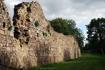
When you reach the play area, go the left of it and follow the track to the right of the wooden fence. At the end of wooden fence follow track as it swings away to the left. Go right at the fork. When you reach a possible exit onto a road, continue straight ahead. Shortly afterwards take the right-hand fork and continue to a plain wooden post where you go straight ahead. At another gateway to the road turn left. When you reach a T-junction go right. At the next gate to the road bear left. When the track narrows take the right-hand fork and follow a corrugated fence passing the cemetery. Go over a footbridge, up a flight of steps and onto the road. Turn left along the road passing the remains of Hartshill Castle back to your starting point.
Please note that near to the starting point of this walk is an information board which gives details of a much longer walk.
Maps 

| Ordnance Survey Explorer 322 | Sheet Map | 1:25k | BUY |
| Anquet OS Explorer 322 | Digital Map | 1:25k | BUY |
| Ordnance Survey Digital Map Subscription | |||
| Latest Ordnance Survey Discounts | |||
Other walks nearby
| Walk 3486 | Sutton Cheney & Market Bosworth | easy/mod | 7.4 miles |
| Walk 2571 | Coventry's Ancient Arden | easy | 4.5 miles |
| Walk 2569 | Longford Urban Circular, Coventry | easy | 4.5 miles |
| Walk 1614 | Meriden & Berkswell Circular | easy/mod | 8.0 miles |
| Walk 1840 | Sharnford & Claybrooke Magna from Sapcote | easy/mod | 10.0 miles |
| Walk 1854 | Coombe Abbey and Country Park | easy/mod | 7.0 miles |
| Walk 3682 | Berkswell Circular (East) | easy | 3.5 miles |
| Walk 3688 | Berkswell West Circular | easy | 5.0 miles |
| Walk 3087 | Normanton Park & Desford Crossroads | moderate | 11.5 miles |
| Walk 3710 | Burton Green & Beechwood Circular | easy/mod | 5.8 miles |
