Walk 1748 - printer friendly version
East Knoyle & Hindon from West Knoyle Walk
Author - Lou Johnson
Length - 9.6 miles / 15.6 km
Ascent - 900 feet / 273 metres
Grade - moderate
Start - OS grid reference ST854319
Lat 51.0862270 + Long -2.2098251
Postcode BA12 6AE (approx. location only)
This Wiltshire walk explores an area of beautiful downland in the Wiltshire Downs AONB. The route includes interesting and picturesque villages, a windmill dating from the 17th century, some glorious views that include neighbouring Dorset. The route needs careful navigation in the initial stages, but the route finding becomes easier in the second half of the route where sections of the Wessex Ridgeway and Monarch's Way long distance paths are used.
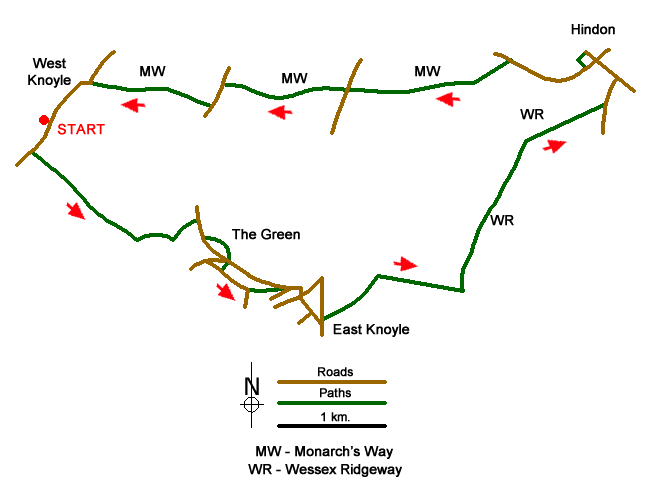
The start is the village of West Knoyle where a small parking area by the children's playground provides space for a few cars (grid ref. ST854319). Take the waymarked path heading south east through a gate adjacent to the playground. Follow this path for about a kilometre to cross Upton Lane (grid ref. ST868312). The path initially follows the edge of Puckwell Coppice (trees to your right) and then passes through Mackintosh Davidson Wood Nature Reserve before reaching open fields and Upton Lane. Briefly bear right and then take the continuing path on your left across a field and through woodland to reach a bridleway (grid ref. ST868310) after 500 metres. Turn left along the bridleway to reach The Green (grid ref. ST871312).
Turn right along Wise Lane. After 400 metres you pass the 17th century windmill on your left. A path leads across grass for closer inspection of this historic building. Return to Wise Lane and continue to a road junction. Turn sharp right and take the signed footpath on the left (grid ref. ST873308). Descend to a lane and turn left. After 300 metres leave the road and follow the path on the left at a fingerpost (grid ref. ST875306). Continue straight along this path back onto Wise Lane. Turn right and follow the lane as it curves to the right and reaches the main road through East Knoyle (grid ref. ST881305). Bear right and follow the main road for 200 metres and turn left down Millbrook Lane (signed as a cul-de-sac) to reach the A350.
Take the signed footpath opposite and slightly to the left. This path enters a field where you go half left. Maintain the same direction across a larger field eventually bearing slightly left towards a track running in front of woodland (grid ref. ST888307). Turn right along the track (tress to your left) for 800 metres to reach a cross track (grid ref. ST896306). Turn left and join the Wessex Ridgeway. After 1.5 km you reach a junction of tracks (grid ref. ST903320). Turn right here to continue along the Wessex Ridgeway to a road. Go left along this road and keep straight ahead to reach the busy High Street in Hinton (grid ref. ST912326).
Turn left along the High Street and turn left into Angel Lane (B3089) after 300 metres. Follow the B3089 for about a kilometre ignoring the road on the left leading to East Knoyle. Turn left onto the Monarch's Way (grid ref. ST901328) and follow the clear track to reach the A350. Go straight across this road and continue on the Monarch's Way for a further kilometre or so to a lane. Turn left. Just before Upton Bottom Farm, take the clear track on the right (grid ref. ST872234). Stay on the Monarch's Way as it veers left and then right to gently descend to a road. Bear left past the church (on your right) and continue along the road back to the start after 800 metres.
Messaging & Social Media
Message Walking Britain and follow the latest news.

Mountain Weather
Stay safe on the mountains with detailed weather forecasts - for iOS devices or for Android devices.