Walk 1757 - printer friendly version
River Ouse & Moor Monkton FROM Nether Poppleton Walk
Author - Andy Chaplin
Length - 10.0 miles / 16.3 km
Ascent - 200 feet / 61 metres
Grade - moderate
Start - OS grid reference SE564550
Lat 53.9879780 + Long -1.1413347
Postcode YO26 6LF (approx. location only)
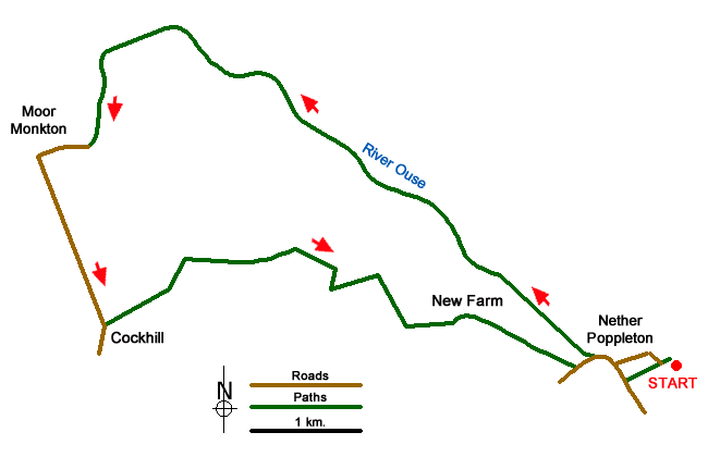
This 10-mile North Yorkshire walk near York is half river walking along the Ouse and then the Nidd with the remaining half agricultural cross-country walking. The paths and tracks are easy to follow apart from one footpath at the end of Scagglethorpe Lane.
There is off road parking on Main Street in Nether Poppleton (grid ref. SE556549), which is on the route of the walk. I chose to park at the Church and Tithe Barn in Nether Poppleton (grid ref. SE564550) which adds an extra mile but gives you the chance to see both of these fine buildings.
From the church walk past the Tithe Barn then take the footpaths straight ahead to Millfield Lane. Turn right and continue along Main Street then off right to the river path. It is signed as the Jorvic Way - the riverside walk to Moor Monkton being a part of the north-west quadrant of the Jorvic Way around York.
It is an easy walk along the Ouse path. Notable on the way is the Redhouse Reservoir which draws water from the Ouse that is then pumped for 28 kilometres to Eccup reservoir, north of Leeds. Also, as you approach the confluence with the river Nidd there are views across the Ouse of Beningbrough Hall and across the Nidd there is Nun Monkton priory.
At the Nidd head south on the path and track alongside the holiday homes towards Moor Monkton. Take the road on the right through the village then follow it south again as it becomes Church Lane. After passing All Saints church and Oaklands turn off left on Red House Lane. After half a mile turn right on the road leading to Thickpenny Farm and Forge.
The track at Thickpenny goes to the left of the new gates, past the buildings and briefly re-joins the road. Carry straight on across the field towards the farm on your right. When you come out onto the end of Scagglethorpe Lane there is a footpath sign for Poppleton. Unfortunately, it seems to point down a drainage ditch. The path goes through the garden of the house to a stile into the field behind.
From here carry on eastwards to Woodhouse Farm then turn south down Lords Lane. After 0.5 km another Poppleton footpath sign shows the path to New Farm. Before reaching the farm stay on the left of the drainage ditch and follow the route around the west and north of the farm buildings. A path heading south east across fields takes you back to Main Street in Nether Poppleton.
Messaging & Social Media
Message Walking Britain and follow the latest news.

Mountain Weather
Stay safe on the mountains with detailed weather forecasts - for iOS devices or for Android devices.