Walk 1765 - printer friendly version
Comb Fell & Hedgehope Hill from Langleeford Walk
Author - Lou Johnson
Length - 8.9 miles / 14.5 km
Ascent - 2200 feet / 667 metres
Grade - mod/hard
Start - OS grid reference NT953225
Lat 55.4962650 + Long -2.0759479
Postcode NE71 6RG (approx. location only)
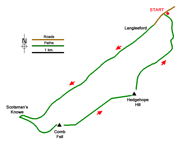
A circular walk from Langleeford visiting the summits of Comb Fell and Hedgehope Hill. The route heads up the Harthope Burn valley climbing gently to reach Scotsman's Knowe. Turning southeast, the walk crosses Comb Fell and continues along the ride to reach Hedgehope Hill. The final descent follows a concessionary path back into the valley. Excellent views, especially from Hedgehope hill, extend to the Northumberland coast and across the valley to The Cheviot.
Start from the roadside parking area (grid ref. NT953225) on the south side of the minor road from Wooler about 600 metres before reaching Langleeford. After parking, head west up the road to Langleeford and take the track through a gate. The clear track up the valley passes farm buildings at Langleeford Hope (grid ref. NT933208). Shortly after the track ends and the route continues on the north side of Harthope Burn. In places the path fades but the route is clear as you walk above the burn down to your left. At steeper section at the head of the valley leads up to a fence at Scotsman's Knowe (grid ref. NT905190).
Initially turn left (southeast) across rough ground following the fence on your right. The route soon veers east staying with the fence to reach the summit of Comb Fell (652 m.). Continue northeast shadowing the fence down to a broad col. Continue with the fence on your right on a sharp climb up to the summit of Hedgehope Hill (714 m.) with its OS trig column on top of the highest rocks. The view from here is excellent and on a clear day the panorama extends to Bamburgh Castle and the Farne Islands as well as across the valley to The Cheviot.
The descent follows a concessionary path that initially descends north before swinging northeast. As you descend you pass the rocky outcrops of Long Crags and the more interesting Housey Crags. The route continues down a good path heading north to reach a footbridge over Harthope Burn and back to the start.
Messaging & Social Media
Message Walking Britain and follow the latest news.

Mountain Weather
Stay safe on the mountains with detailed weather forecasts - for iOS devices or for Android devices.