Comb Fell & Hedgehope Hill from Langleeford
Northumberland Walk
Nat Park - Northumberland
County/Area - Northumberland County
Author - Lou Johnson
Length - 8.9 miles / 14.5 km Ascent - 2200 feet / 667 metres
Time - 6 hours 40 minutes Grade - mod/hard
Walk Route Description
Click image to see photo description.
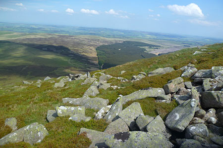
A circular walk from Langleeford visiting the summits of Comb Fell and Hedgehope Hill. The route heads up the Harthope Burn valley climbing gently to reach Scotsman's Knowe. Turning southeast, the walk crosses Comb Fell and continues along the ride to reach Hedgehope Hill. The final descent follows a concessionary path back into the valley. Excellent views, especially from Hedgehope hill, extend to the Northumberland coast and across the valley to The Cheviot.
Start from the roadside parking area (grid ref. NT953225) on the south side of the minor road from Wooler about 600 metres before reaching Langleeford. After parking, head west up the road to Langleeford and take the track through a gate. The clear track up the valley passes farm buildings at Langleeford Hope (grid ref. NT933208). Shortly after the track ends and the route continues on the north side of Harthope Burn. In places the path fades but the route is clear as you walk above the burn down to your left. At steeper section at the head of the valley leads up to a fence at Scotsman's Knowe (grid ref. NT905190).
Initially turn left (southeast) across rough ground following the fence on your right. The route soon veers east staying with the fence to reach the summit of Comb Fell (652 m.). Continue northeast shadowing the fence down to a broad col. Continue with the fence on your right on a sharp climb up to the summit of Hedgehope Hill (714 m.) with its OS trig column on top of the highest rocks. The view from here is excellent and on a clear day the panorama extends to Bamburgh Castle and the Farne Islands as well as across the valley to The Cheviot.
The descent follows a concessionary path that initially descends north before swinging northeast. As you descend you pass the rocky outcrops of Long Crags and the more interesting Housey Crags. The route continues down a good path heading north to reach a footbridge over Harthope Burn and back to the start.
Maps 

| Ordnance Survey Explorer OL16 | Sheet Map | 1:25k | BUY |
| Anquet OS Explorer OL16 | Digital Map | 1:25k | BUY |
| Ordnance Survey Digital Map Subscription | |||
| Latest Ordnance Survey Discounts | |||
Other walks nearby
| Walk 1766 | Cushat Law and Bloodybush Edge from Hartside | mod/hard | 12.5 miles |
| Walk 2299 | The Cheviot | moderate | 9.0 miles |
| Walk 1314 | Great Hetha and Elsdon Burn from Hethpool | easy/mod | 4.0 miles |
| Walk 3644 | Blackhaggs Rigg & Great Hetha from Hethpool | moderate | 9.6 miles |
| Walk 3646 | Hethpool, Sutherland Bridge & Great Hetha | moderate | 6.0 miles |
| Walk 3739 | Elsdonburn & Trowupburn from Hethpool | moderate | 8.2 miles |
| Walk 1805 | An introduction to the Breamish Valley | easy | 2.0 miles |
| Walk 2677 | Circuit of Doddington Moor | easy | 3.8 miles |
| Walk 1201 | Black Hag from Kirk Yetholm | moderate | 8.5 miles |
| Walk 1200 | Windy Gyle | moderate | 7.5 miles |
Recommended Books & eBooks
Walking in Northumberland
 This guidebook contains detailed route descriptions for 36 day walks in Northumberland including the Cheviot Hills. The terrain varies from wild walks and craggy ascents to gentle riverside strolls. Each route ranges from 4 to 16 miles in length and there is the opportunity to link several walks together to create longer treks.
More information
Hadrian's Wall Path
 Hadrians Wall Path guidebook to walk the 84 mile National Trail. Described in both directions, the main description is west to east between Bowness-on-Solway and Wallsend, Newcastle, with extensions to Maryport and South Shields. With extensive historical information related to this World Heritage site and separate 1:25,000 OS map booklet included.
More information
