Walk 1766 - printer friendly version
Cushat Law and Bloodybush Edge from Hartside Walk
Author - Lou Johnson
Length - 12.5 miles / 20.3 km
Ascent - 2200 feet / 667 metres
Grade - mod/hard
Start - OS grid reference NT976162
Lat 55.4396740 + Long -2.0394861
Postcode NE66 4LY (approx. location only)
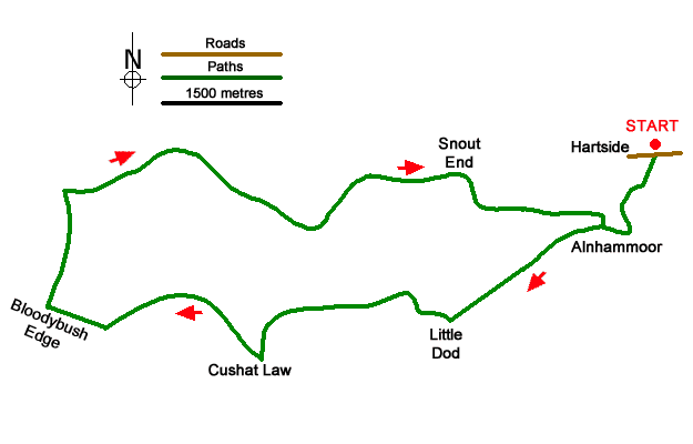
This Northumberland walk from Hartside approaches the summits of Cushat Law (615 m.) and Bloodybush Edge (610 m.) from the east. The route needs careful navigation as there are many tracks and paths crossing this area so the relevant OS 1:25k map is essential. The route initially heads for Alnhammoor before striking southwest to Little Dod. The walk continues across unpathed moor to reach Cushat Law. The route then turns north over Bloodybush Edge and into the Breamish Valley to return to the start.
The start is the roadside parking at Hartside (grid ref. NT976162) in the Breamish Valley. After parking turn left down a tarmac track (signed to Little Dod) and follow this through to Alnhammoor. Just before reaching the farm, leave the track and follow the path on the left across a field to a gate. Turn right and walk beside the wall to a wall corner (grid ref. NT972153) following a track. Where the track bends right, continue ahead on a clear path that runs parallel to the River Breamish on your right.
After 300 metres the path crosses a stream and then veers southwest. Maintain direction for two kilometres to cross the northern flank of Little Dod and a track (grid ref. NT951143). Note that on this section there are places where the path fades. Turn right onto the clear track and continue for 700 metres to pass through a gate (grid ref. NT945146). Just past the gate turn left and walk over unpathed ground onto Bush Knowe. Continue west keeping to the broad ridge before veering south the summit of Cushat Law (grid ref. NT928137) where you can enjoy an extensive view.
Turn right long the fence and continue northwest and then west to pick up a good path leading to the summit of Bloodybush Edge with its OS trig column. From the summit head north shadowing the fence dropping down to reach Salter's Road (grid ref NT905158). Turn right and continue to descend on a clear path into the Breamish Valley (grid ref. NT920163). Bear right and follow the river downstream on a clear track to reach a group of farm buildings (grid ref. NT9434153). Ignore the track on the right and follow the main track as it swings north-east beside the river into a steep sided valley.
The track veers east and climbs away from the river across Snout End before descending to Alnhammoor Farm where you re-join the outward route back to the start.
Messaging & Social Media
Message Walking Britain and follow the latest news.

Mountain Weather
Stay safe on the mountains with detailed weather forecasts - for iOS devices or for Android devices.