Walk 1769 - printer friendly version
Suilven (North-western approach) Walk
Author - Lou Johnson
Length - 12.0 miles / 19.5 km
Ascent - 2700 feet / 818 metres
Grade - hard
Start - OS grid reference NC107219
Lat 58.1453380 + Long -5.2179281
Postcode IV27 4LW (approx. location only)
This walk to the summit of Suilven (Caisteal Liath) follows an approach from the northwest. This a challenging route across a confusing landscape of hills and lochs that can be very disorientating in poor visibility. A full day excursion, you need to be competent at navigation and carry an appropriate 1:25 k map. Suilven is a dramatic hill rising steeply from the surrounding landscape. The final ascent (and descent) is tough, although the rewards when reaching the summit more than recompense for the effort.
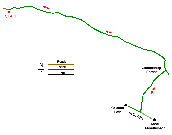
The start is the parking area (grid ref. NC107219) at the end of the road leading to Glencanisp Lodge, which lies a few miles east of Lochinver. After parking walk east and continue to the end of the public road. Enter the grounds of Glencanisp Lodge and bear left (signed footpath) where the track forks. Continue behind the lodge following signs. Continue on track beyond heading right by sign for 'River Inver'. Descend and veer left at next fork (by bench). Leave the lochside through a gap and continue on a track with a deer fence on your right.
Reaching the end of the fence on your right, continue ahead on a rough but clear track. Pass a loch on your right. Ignore a shooting track on the right and maintain direction to reach a junction at Suileag (grid ref. NC148210). Go straight ahead here passing a wall on your left. Cross a stream and continue along an undulating track to reach the shores of Lochan Buidhe. The track then continues to reach a bridge (grid ref. NC169195).
Continue ahead on the track, which rises and then descends to reach a cairn and path junction (grid ref. NC167196). Leave the track and follow path south (not shown on OS 1.25k map). Continue up into a small depression to a cairn. Again, continue ahead to another cairn, pass a small lochan and rise to a third cairn. The path passes through a col between two grassy hummocks before descending to bear right past a loch. Continue half left between two lochs (grid ref. NC159187) crossing a stream.
Continue up a path towards the wide gully that climbs Suilven's north side. After reaching the base of the gully, climb steeply up a rough path to pass between two rocky walls before zigzagging up rough ground to reach Bealach Mor (grid ref. NC158181). You are now on Suilven's main ridge. Turn right up steep path with some low-grade scrambles over rocks. The path soon follows a narrow ridge and then zigzags before a short descent to a narrow col. Continue ahead on a steep path and head left past a large rock outcrop. Then go right up a rough gully and negotiate some rock outcrops to finally reach the cairn on Caisteal Liath (731 m.), Suilven's westerly and highest summit. A short walk beyond the cairn provides the best views. To return to the start follow the outward route. However, do take care on the descent especially down steep paths.
Messaging & Social Media
Message Walking Britain and follow the latest news.

Mountain Weather
Stay safe on the mountains with detailed weather forecasts - for iOS devices or for Android devices.