Suilven (North-western approach)
Highland Walk
County/Area - Highland - Northern Highland
Author - Lou Johnson
Length - 12.0 miles / 19.5 km Ascent - 2700 feet / 818 metres
Time - 8 hours 40 minutes Grade - hard
Walk Route Description
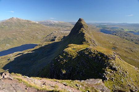
Click image to see photo description.
This walk to the summit of Suilven (Caisteal Liath) follows an approach from the northwest. This a challenging route across a confusing landscape of hills and lochs that can be very disorientating in poor visibility. A full day excursion, you need to be competent at navigation and carry an appropriate 1:25 k map. Suilven is a dramatic hill rising steeply from the surrounding landscape. The final ascent (and descent) is tough, although the rewards when reaching the summit more than recompense for the effort.
The start is the parking area (grid ref. NC107219) at the end of the road leading to Glencanisp Lodge, which lies a few miles east of Lochinver. After parking walk east and continue to the end of the public road. Enter the grounds of Glencanisp Lodge and bear left (signed footpath) where the track forks. Continue behind the lodge following signs. Continue on track beyond heading right by sign for 'River Inver'. Descend and veer left at next fork (by bench). Leave the lochside through a gap and continue on a track with a deer fence on your right.
Reaching the end of the fence on your right, continue ahead on a rough but clear track. Pass a loch on your right. Ignore a shooting track on the right and maintain direction to reach a junction at Suileag (grid ref. NC148210). Go straight ahead here passing a wall on your left. Cross a stream and continue along an undulating track to reach the shores of Lochan Buidhe. The track then continues to reach a bridge (grid ref. NC169195).
Continue ahead on the track, which rises and then descends to reach a cairn and path junction (grid ref. NC167196). Leave the track and follow path south (not shown on OS 1.25k map). Continue up into a small depression to a cairn. Again, continue ahead to another cairn, pass a small lochan and rise to a third cairn. The path passes through a col between two grassy hummocks before descending to bear right past a loch. Continue half left between two lochs (grid ref. NC159187) crossing a stream.
Continue up a path towards the wide gully that climbs Suilven's north side. After reaching the base of the gully, climb steeply up a rough path to pass between two rocky walls before zigzagging up rough ground to reach Bealach Mor (grid ref. NC158181). You are now on Suilven's main ridge. Turn right up steep path with some low-grade scrambles over rocks. The path soon follows a narrow ridge and then zigzags before a short descent to a narrow col. Continue ahead on a steep path and head left past a large rock outcrop. Then go right up a rough gully and negotiate some rock outcrops to finally reach the cairn on Caisteal Liath (731 m.), Suilven's westerly and highest summit. A short walk beyond the cairn provides the best views. To return to the start follow the outward route. However, do take care on the descent especially down steep paths.
Maps 

| Ordnance Survey Explorer 442 | Sheet Map | 1:25k | BUY |
| Anquet OS Explorer 442 | Digital Map | 1:25k | BUY |
| Ordnance Survey Digital Map Subscription | |||
| Latest Ordnance Survey Discounts | |||
Other walks nearby
| Walk 1316 | Falls of Kirkaig | easy | 5.8 miles |
| Walk 1312 | Achmelvich Bay and Alltanabradhan | easy | 3.0 miles |
| Walk 2529 | Stac Pollaidh Circular | easy/mod | 2.8 miles |
| Walk 1017 | Stac Pollaidh | easy/mod | 3.0 miles |
| Walk 1317 | Sail Gharbh (Quinag) | moderate | 5.4 miles |
| Walk 3272 | Conival & Ben More Assynt from Inchnadamph | hard | 11.0 miles |
| Walk 1117 | Glas Bheinn & Eas a' Chual Aluinn (waterfall) | mod/hard | 8.5 miles |
| Walk 1266 | The Old Man of Stoer and the Point of Stoer | easy | 4.5 miles |
| Walk 1319 | The Bone Caves of Inchnadamph | easy | 3.0 miles |
| Walk 2274 | Cul Mor from Knockan Crag | mod/hard | 8.5 miles |
Recommended Books & eBooks
Walking in Torridon
 This guidebook contains 52 day walks in Torridon, a remote and much-loved area of the Scottish Highlands. Based around Shieldaig and Slioch, the routes are split into 3 sections: easy walks, long and high level walks and mountain ascents over 2000ft including 9 Munros, and 5 outline suggestions for major ridge walks.
More information
Skye's Cuillin Ridge Traverse
 This 2-volume set provides all the information required to complete the main ridge traverse on Skye's Black Cuillin. Strategy, gear, training, navigation and logistics are covered, and 10 classic scrambles are described. A lightweight second guidebook gives the scrambler detailed maps, topos and route description for the ridge traverse itself.
More information
