Walk 1775 - printer friendly version
Walberswick Circular Walk
Author - Lou Johnson
Length - 4.5 miles / 7.3 km
Ascent - 100 feet / 30 metres
Grade - easy
Start - OS grid reference TM500748
Lat 52.3143330 + Long 1.6664743
Postcode IP18 6TJ (approx. location only)
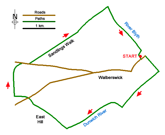
A pleasant circular walk from Walberswick on the Suffolk Coast. The route includes a beach, salt marshes, heathland, old windmills, and the estuary of the River Blyth. The walk starts from the free car park on Ferry Road, Walberswick (grid ref. TM500748). After parking walk to the eastern end of the car park and walk towards the beach across a bridge over the River Dunwich. Continue ahead through the dunes to the beach and turn right along the head of the beach.
Continue with the sea on your left passing beach huts on your right. After 800 metres (before information board) turn right towards two footbridges. Cross the first and continue to the second. Do not cross this bridge but turn left along the riverbank. Continue on a boardwalk with water to your left and follow the signs for the Suffolk Coast Path.
Reaching a ruined mill (grid ref. TM487737), leave the Coast Path and turn right along a gravel path between salt marshes (Oldtown Marshes). Reaching trees bear left through a gate and then turn right along the edge of Sheep Hill keeping a fence on your right. Veer right through a kissing gate and continue to Lodge Road (grid ref. TM480742).
Cross Lodge Road and go half left on the bridleway opposite. Continue to reach the edge of a wood (Sallow Wood Covert) and bear right with the trees on your left. Continue to the end of the wood. Follow path right (signed to Sandlings Walk) and continue through a gate. Continue across a field to reach the B1387 by Eastwood Lodge. Turn right along the road and then left onto a bridleway (again signed Sandlings Walk). Follow the clear path across Walberswick Common keeping ahead to join tarmac Palmer's Lane.
Follow this lane to reach the River Blyth. Do not cross the bridge and turn right with river on your left. Continue along the river back to the start.
Messaging & Social Media
Message Walking Britain and follow the latest news.

Mountain Weather
Stay safe on the mountains with detailed weather forecasts - for iOS devices or for Android devices.