Walk 1791 - printer friendly version
Tarbat Ness from Porthmahomack Walk
Author - Lou Johnson
Length - 9.0 miles / 14.6 km
Ascent - 500 feet / 152 metres
Grade - moderate
Start - OS grid reference NH914842
Lat 57.8341150 + Long -3.8305793
Postcode IV20 1YP (approx. location only)
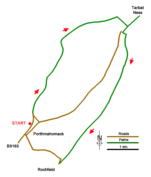
This walk from the quiet fishing village of Portmahomack explores the low-lying Tarbat Peninsula which juts out into the North Sea between the Dornoch Firth and the Moray Firth. The route offers superb views across the Dornoch Firth, passes the lighthouse providing guidance for shipping in these often-treacherous waters and in Spring offers the chance to see breeding seabirds.
The start is the car park behind the beach in Porthmahomack (grid ref. NH914842). After parking walk north (sea to left) and continue to the small harbour. Continue past the harbour to reach the end of the road with a row of bungalows on your right. Bear left and pass through the gate to join a grassy path. In places the path fades so keep close to the rocky shore soon passing through another gate. Continue along the shore to cross a stile.
As you head north, enjoy the views across Dornoch Forth towards the Caithness coast. Reaching a fence running parallel to the coast, stay on the left-hand side of the fence to reach a small both and a selection of rusty anchors. Continue along a grassy track bearing right through gorse where the track forks (grid ref. NH925870). Pass through a gate and follow the top of bank for about two kilometres passing a lochan on your right to reach a fence across the path (NH942876). Turn right and with fence on your right past small plantation to a wall. Turn right along the wall to reach a road (grid ref. NH943872).
Turn left along the road to a gate. Pass through the gate and continue along the track past the lighthouse to reach Tarbat Ness. In fine weather, it is a splendid place for a break and to spend some time taking in the glorious view. Retrace your steps back past the lighthouse and through the gate onto the public road. Pass the small car park on the left and continue to a T-junction. Turn left (path signed to Rockfield 5km) and continue down to a small cottage and a quay. Just before the quay (grid ref. NH944872), turn right through a gate to join the coast path.
Follow the path south and bear right to cross Tigh na Creige headland before returning to the shoreline. After three kilometres you pass restored Ballone Castle on your right. Stay on the shore and continue ahead with the community of Rockfield coming into view. Continue beside the sea to reach a road in Rockfield (grid ref. NH924830). Turn right and follow the lane across the peninsula and back to Portmahomack.
Messaging & Social Media
Message Walking Britain and follow the latest news.

Mountain Weather
Stay safe on the mountains with detailed weather forecasts - for iOS devices or for Android devices.