Tarbat Ness from Porthmahomack
Highland Walk
County/Area - Highland - Central Highland
Author - Lou Johnson
Length - 9.0 miles / 14.6 km Ascent - 500 feet / 152 metres
Time - 5 hours 0 minutes Grade - moderate
Walk Route Description
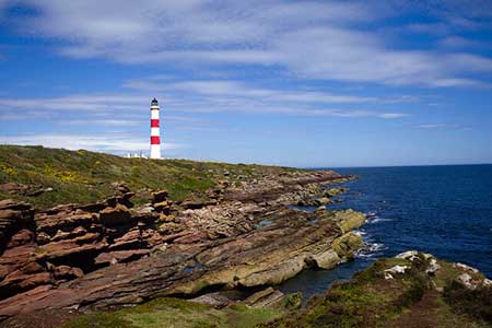
Click image to see photo description.
This walk from the quiet fishing village of Portmahomack explores the low-lying Tarbat Peninsula which juts out into the North Sea between the Dornoch Firth and the Moray Firth. The route offers superb views across the Dornoch Firth, passes the lighthouse providing guidance for shipping in these often-treacherous waters and in Spring offers the chance to see breeding seabirds.
The start is the car park behind the beach in Porthmahomack (grid ref. NH914842). After parking walk north (sea to left) and continue to the small harbour. Continue past the harbour to reach the end of the road with a row of bungalows on your right. Bear left and pass through the gate to join a grassy path. In places the path fades so keep close to the rocky shore soon passing through another gate. Continue along the shore to cross a stile.
As you head north, enjoy the views across Dornoch Forth towards the Caithness coast. Reaching a fence running parallel to the coast, stay on the left-hand side of the fence to reach a small both and a selection of rusty anchors. Continue along a grassy track bearing right through gorse where the track forks (grid ref. NH925870). Pass through a gate and follow the top of bank for about two kilometres passing a lochan on your right to reach a fence across the path (NH942876). Turn right and with fence on your right past small plantation to a wall. Turn right along the wall to reach a road (grid ref. NH943872).
Turn left along the road to a gate. Pass through the gate and continue along the track past the lighthouse to reach Tarbat Ness. In fine weather, it is a splendid place for a break and to spend some time taking in the glorious view. Retrace your steps back past the lighthouse and through the gate onto the public road. Pass the small car park on the left and continue to a T-junction. Turn left (path signed to Rockfield 5km) and continue down to a small cottage and a quay. Just before the quay (grid ref. NH944872), turn right through a gate to join the coast path.
Follow the path south and bear right to cross Tigh na Creige headland before returning to the shoreline. After three kilometres you pass restored Ballone Castle on your right. Stay on the shore and continue ahead with the community of Rockfield coming into view. Continue beside the sea to reach a road in Rockfield (grid ref. NH924830). Turn right and follow the lane across the peninsula and back to Portmahomack.
Maps 

| Ordnance Survey Explorer 438 | Sheet Map | 1:25k | BUY |
| Anquet OS Explorer 438 | Digital Map | 1:25k | BUY |
| Ordnance Survey Digital Map Subscription | |||
| Latest Ordnance Survey Discounts | |||
Other walks nearby
| Walk 3101 | Ben Bhraggie traverse | easy/mod | 4.7 miles |
| Walk 2504 | Struie circular | easy/mod | 4.5 miles |
| Walk 3287 | Morven, Smean & Maiden Pap | hard | 10.2 miles |
| Walk 1773 | Ben Wyvis (western approach) | mod/hard | 8.0 miles |
| Walk 1530 | Little Wyvis ascent from near Garve | moderate | 6.4 miles |
| Walk 1897 | Sandend to Cullen Coast Path | easy/mod | 5.0 miles |
| Walk 1956 | Moray Coast Trail - Cullen to Portessie | easy/mod | 6.3 miles |
| Walk 1777 | Carn Daimh from Glenlivet | moderate | 8.5 miles |
| Walk 2031 | Abernethy Forest, Cairngorms | easy/mod | 10.2 miles |
| Walk 1771 | Ladder Hills Circular | mod/hard | 9.5 miles |
Recommended Books & eBooks
Great Mountain Days in Scotland
 Inspirational guidebook to 50 challenging routes for mountaineers, scramblers, hillwalkers and fell runners, many long enough to backpack over 2 days, especially in winter (12 to 25 miles). A mix of classic routes and unsung gems across Scotland from Galloway to the Outer Hebrides in widely differing wild landscapes. With customised OS mapping.
More information
Skye's Cuillin Ridge Traverse
 This 2-volume set provides all the information required to complete the main ridge traverse on Skye's Black Cuillin. Strategy, gear, training, navigation and logistics are covered, and 10 classic scrambles are described. A lightweight second guidebook gives the scrambler detailed maps, topos and route description for the ridge traverse itself.
More information
