Walk 1800 - printer friendly version
West of Harrogate without a car Walk
Author - Peter Schofield
Length - 9.0 miles / 14.6 km
Ascent - 920 feet / 279 metres
Grade - easy/mod
Start - OS grid reference SE281541
Lat 53.982197 + Long -1.5729998
Postcode HG3 1QB (approx. location only)
If you are looking for undemanding walking offering expansive views in pleasant countryside, the area around Harrogate will meet your needs. In clear weather, parts of both the North York Moors and the Dales can be seen from many points on this walk.
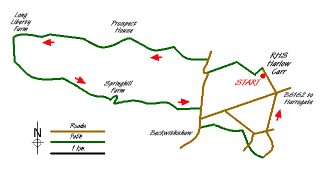
The walk starts at the Royal Horticultural Society garden at Harlow Carr (Grid ref. SE281541). From the main entrance, turn left along Crag Lane and after 200m, go left down a lane past "The Harrogate Arms" PH towards a gate leading towards the RHS workshop. You are now on the Dales Way Link footpath which is followed for the next 6km. Take a waymarked path to the right of the workshop gate which leads through an attractive wooded area. Ignoring routes to right and left, follow the path through the woods to arrive at a house on the B6161 road. Turn right on to the road and after 300m, go left on to a farm access track at another Dales Way Link sign.
Continue past a couple of farms and after 0.8K where the track goes through a gate alongside a wood, go left over a stile. The route continues as a field path offering easy and generally good walking conditions, turning to tarmac at Whin Hill Farm (Grid ref. SE254548). After passing a couple of houses, the field path returns, arriving at the access road to Long Liberty Farm after 1.5km. Go left down the road and after 100m, the Dales Way Link goes off to the right. Our route continues straight on over a stile and down the hill towards Oak Beck to join the water company access road from Beaver Dyke reservoir. A wide variety of birds can be seen in this pretty valley.
Turn left following the access road through the wood for 200m where an arrow painted on a tree indicates a path uphill to the left (Grid ref. SE231544). Take the path, crossing a stile at the top of the rise to enter an open field offering views back towards the southern Dales. Follow the clear route across the field for 200m to a gate, to join a track heading towards a ruined building on the right. Just beyond the building, the track splits and our route goes right, the track to the left not being a Right of Way.
The track is followed for a further 1.2km to Springhill Farm and a wide panorama to the north and east opens up as far as the North York Moors, the distinctive feature of the Kilburn White Horse being clearly visible in good weather. In contrast, the "giant's golf balls" at the Menwith Hill communications centre provide a pointed reminder of more contemporary issues. At the farm, turn sharp right on to a track going down hill across a stream, following it for 2km to meet the B6161 road just north of the village of Beckwithshaw. Turn right down the road and continue for 350m to reach the parish church on the left hand side. Immediately beyond the church wall, go left on a path between the wall and a house. Cross over a stile and continue straight ahead across a field for 300m to reach another stile at a lane. Go left and immediately right through a gate in a hedge into the garden of a private house.
Leaving the garden at a stile, follow the clear route across several fields to a path junction (Grid ref. SE276530). Go right, crossing straight over an access road to a private house to reach a lane after a further 300m. Turn right and after 50m, left down to Low House Farm, continuing past the farm and up the hill to a prominent signpost adjacent to a house (Grid ref. SE280525). Go left past the house where the route shortly becomes a tarmac lane. Continue along the lane, crossing two road junctions to arrive back at the start point at Harlow Carr Garden after a further 1.6K.
Harlow Carr is well worth a visit in its own right and has something to offer garden enthusiasts at any time of the year. For those without their own transport, Harrogate & District route 106 stops 200m from the start point and goes to the bus and train stations every twenty minutes (half hourly on Sundays).
Messaging & Social Media
Message Walking Britain and follow the latest news.

Mountain Weather
Stay safe on the mountains with detailed weather forecasts - for iOS devices or for Android devices.