Walk 1838 - printer friendly version
Bateman's & Holton Hill Walk
Author - Lou Johnson
Length - 5.3 miles / 8.6 km
Ascent - 550 feet / 167 metres
Grade - easy
Start - OS grid reference TQ673246
Lat 50.9964770 + Long 0.3827411
Postcode TN19 7EX (approx. location only)
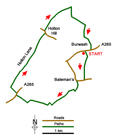
A walk in the East Sussex Weald that offers the opportunity to visit Bateman's, Rudyard Kipling's former home that is now owned by the National Trust. The walk crosses pleasant rolling countryside using field paths and bridleways starting from the village of Burwash on the A265. The start is the small free car park adjacent to the Bear Inn (grid ref. TQ673246).
After parking locate the signed footpath behind the toilets. Follow this path downhill to a junction of paths. Bear right following the orange waymarks to reach a lane (grid ref. TQ673238). Turn right along the lane with the large house of Bateman's soon coming into view. (A visit here is highly recommended.) To continue the walk, turn left down the 'no through road'. At the first junction (grid ref. TQ670235) turn right and follow the past to the Mill Pond. The next section of the onward route is marked by NT pink waymarks. At the first junction keep straight ahead (grid ref. TQ668234). Continue ahead where a path comes in from the left and cross a footbridge on the right. Bear left and continue through Bog Wood to the next junction of paths (grid ref. TQ658233).
Turn left here (Note - do not follow the pink waymarks from this point) and soon bear right passing houses to reach the A265. Cross the main road with care and turn right (east) and soon bear left onto a signed bridleway - Holton Lane - which is followed for just under 2 kilometres to a lane at Holton Hill (grid ref. TQ662251). Turn left along the lane and almost immediately right onto a bridleway by Franchise Lodge. The drive splits after 350 metres (grid ref. TQ663255). Take the waymarked path heading northeast which leads through fields down to Seller's Brook (grid ref. TQ669259).
Turn right alongside Seller's Brook and reaching a footbridge and path junction bear left. Follow the path ahead to reach Ham Lane (grid ref. TQ673254). Turn right along Ham Lane and continue to reach the A265. Turn right and the start of the walk is some metres along the main road on the left.
Messaging & Social Media
Message Walking Britain and follow the latest news.

Mountain Weather
Stay safe on the mountains with detailed weather forecasts - for iOS devices or for Android devices.