Walk 1850 - printer friendly version
Great Hill & Anglezarke Reservoir Walk
Author - Lou Johnson
Length - 9.0 miles / 14.6 km
Ascent - 1200 feet / 364 metres
Grade - moderate
Start - OS grid reference SD620161
Lat 53.6400250 + Long -2.5762275
Postcode PR6 9DQ (approx. location only)
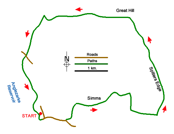
Starting from Anglezarke Reservoir this walk explores the West Pennine Moors including Great Hill and Spitlers Edge. The route explores an area that was once a hive of activity with farms, mines, and small quarries. The walk also passes three reservoirs that were built to provide water to the expanding urban populations and industries of Lancashire.
The start is the Anglezarke car park (grid ref. SD620161). After parking return to the entrance and follow the tarmac access road down to the shore of Anglezarke Reservoir. Continue along the access road with the reservoir on your right. Continue ahead when a road joins from the left. At the next junction (with a small green) bear left and follow the road uphill to pass beside Yarrow Reservoir on your tight. Continue to where the road bends sharp right across Alance Bridge. Go through the metal gate to join a track (grid ref. SD627160).
The track soon crosses a bridge to the east bank of the river and continues to reach a fork at the foot of Lead Mines Clough. On your left is a memorial to a Welling bomber crew that crashed in 1943. To continue bear right at the fork and climb up to a gate. Continue ahead on the track for just over two kilometres to reach the ruined farm of Lower Hempshaw (grid ref. SD647164). After 200 metres the track bends right with the ruins of Upper Hempshaw on your left. Turn left off the track and join a rising grassy path with a wall to your left. Continue ahead through a wall gap and continue to climb up to a cross wall (grid ref. SD654162).
Turn left onto a paved path that initially climbs across Hordern Pasture to a stile. Cross the stile and then continue over Spitlers Edge. After a short descent, the path crosses Redmond's Edge with Great Hill appearing ahead. Continue to another stile and then make the short ascent to the summit of Great Hill with its stone wall shelter (grid ref. SD646191). Take time to enjoy the view across the West Pennine Moors. Turn left onto an initially paved path that descends to a track (grid ref. SD640190). Bear right onto the track Just after passing the ruins of Drinkwaters Farm pass through trees to reach a fork (grid ref. SD634192). Bear left (signed to White Coppice).
After passing the ruins of Coppice Stile Farm, the path drops steeply before swinging left beside the Goit, which is an aqueduct linking Roddlesworth and Anglezarke Reservoirs. Continue ahead at the bridge on your right and follow the valley path passing Stronstrey Bank on your left before the path reaches a lane (grid ref. SD616179). Bear left and then right through a kissing gate. The onward path passes through trees with the reservoir down to your right, crosses fields before entering more woodland. The path descends briefly to a stream before rising to a junction (grid ref. SD618170). Turn left up a grassy bank and follow the path above High Bullough Reservoir. At the end of the reservoir the path descends to a track. Bear left and follow it back along Anglezarke Reservoir to the car park access drive. Turn left back to the start.
Messaging & Social Media
Message Walking Britain and follow the latest news.

Mountain Weather
Stay safe on the mountains with detailed weather forecasts - for iOS devices or for Android devices.