Walk 1876 - printer friendly version
Breidden Hill from Middletown Walk
Author - Lou Johnson
Length - 6.5 miles / 10.6 km
Ascent - 1800 feet / 545 metres
Grade - moderate
Start - OS grid reference SJ301125
Lat 52.7056360 + Long -3.0359671
Postcode SY21 8EL (approx. location only)
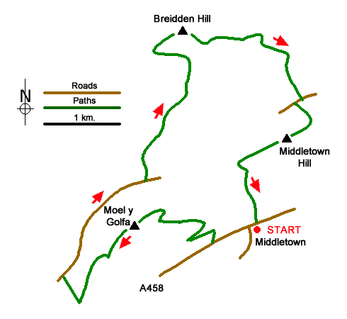
This vigorous walk explores the Breidden Hills which lie on the north side of the A458 between Shrewsbury and Welshpool. Formed of volcanic rock the hills offer excellent views across the surrounding countryside. The first summit reached, Moel y Golfa, is topped by a Romany memorial. Breidden hill, the second summit visited, has a large pillar dedicated to Sir George Bridges Rodney whilst the final summit, Middletown Hill, was home to an extensive Iron Age fort. It is worth noting that the relevant 1:25000 map is especially useful on this walk.
The start is public car park opposite the Breidden pub in the centre of the village (grid ref. SJ301125). After parking walk to the main road and turn left towards Welshpool. Keep to the grass verge on this often busy road and continue for 300 metres to turn right up a tarmac drive towards a large house. Before reaching the house turn left onto the signed footpath leading up a field into trees and path junction (grid ref. SJ296124). Go half right on a path rising across the hillside. The path soon bears sharp left and continues climbing. Nearing the top of the climb the path bears right and reaches more open ground. The path then bends left and shortly afterwards left again to lead you to the memorial and the summit of Moel y Golfa.
Continue ahead south-west along the ridge before descending more steeply downhill to a path junction (grid ref. SJ285118). Turn right and continue downhill to reach Shepherd's Lane (grid ref. SJ283120). Turn right up the lane and continue for about 1.5 kilometres to turn left onto a bridleway. Follow the track between hedges past a house on the right to reach a cottage (grid ref. SJ291132). Pass to the left of the cottage and turn right onto a rising grassy track. Stay on the track for about 400 metres and then fork left off the track to continue along the bridleway (careful navigation required here). Stay on the bridleway for a kilometre to reach a forest track (grid ref. SJ296141).
Cross the forest track and walk left to reach the rim of a large quarry. Bear right and continue uphill to the summit of Breidden Hill and Rodney's Monument. Descend on a clear path south-east. After a steep descend the path veers east. Maintain direction for 500 metres to reach a junction of paths (grid ref. SJ303144). From the junction go half right along a bridleway which soon crosses a forest track. Cross the track and continue to reach open fields. Cross a small stream and turn right onto a path heading south. This path joins a clear track that leads to a lane by Belle Isle Farm (grid ref. SJ307138).
Turn right along the lane and then first left along a tarmac driveway. Continue up the path to a col with Bulthy Hill on the left and, our final objective, Middletown Hill on the right. The England Wales border passes through this col. From the col turn right and complete the steep climb onto Middletown Hill which was once the site of an Iron Age fort. The view is superb and includes most of the walk. Continue across the hill and descend a good path down into another col (grid ref. SJ301131). Turn left and descend steeply back to the A458 and Middletown village. Reaching the main road turn right and the car park used at the start is a short distance away.
Messaging & Social Media
Message Walking Britain and follow the latest news.

Mountain Weather
Stay safe on the mountains with detailed weather forecasts - for iOS devices or for Android devices.