The Butt of Lewis from Eoropie
Outer Hebrides Walk
County/Area - Outer Hebrides
Author - Lou Johnson
Length - 3.8 miles / 6.2 km Ascent - 200 feet / 61 metres
Time - 2 hours 10 minutes Grade - easy
Walk Route Description
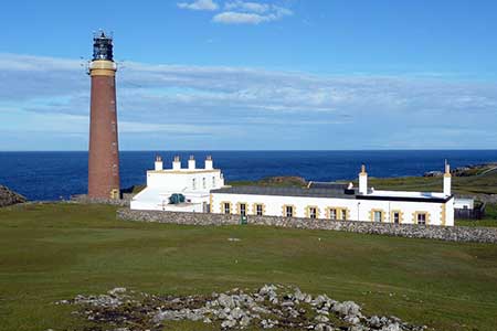
Click image to see photo description.
This short walk from Eoropie explores the northernmost land in the Outer Hebrides on the Isle of Lewis. The route visits the beach and sand dunes at Eoropie before following a waymarked path that clings to the top of the cliffs to reach the Butt of Lewis with its lighthouse. The return to Eoropie follows a quiet road back into the village passing a patchwork of narrow fields typical of this area.
The start is the small car park behind the beach at Eoropie (grid ref. NB518648), which is signed off the B8103. After parking head towards the dunes and beach. Just after passing some picnic benches by stone walls, turn right off the tarmac onto a grassy path. Pass through a gate and continue down to the back of the beach to reach a stone bench. Follow the shoreline and pass through a gate in a fence. The coast path is waymarked and follows the top of the rugged cliffs for three kilometres to reach the lighthouse at Butt of Lewis (grid ref. NB520665). This exposed headland must see wild weather during the year with no protection from Atlantic storms and high seas.
It is worth spending som exploring the headland before turning south and walking parallel to the road with the sea on your immediate left. After 500 metres or so bear left to the road and follow it back into Eoropie across a wild windswept moor with a few grazing sheep the only sign of life. The road climbs a little before the houses at Eoropie come into view. Continue ahead at a crossroads and follow the B8103 around to the left. After 250 metres turn right to the car park.
Maps 

| Ordnance Survey Explorer 460 | Sheet Map | 1:25k | BUY |
| Anquet OS Explorer 460 | Digital Map | 1:25k | BUY |
| Ordnance Survey Digital Map Subscription | |||
| Latest Ordnance Survey Discounts | |||
Other walks nearby
| Walk 1266 | The Old Man of Stoer and the Point of Stoer | easy | 4.5 miles |
| Walk 3261 | Handa Island - Scottish Wildlife Trust | easy | 4.0 miles |
| Walk 1312 | Achmelvich Bay and Alltanabradhan | easy | 3.0 miles |
| Walk 1318 | Sandwood Bay | moderate | 10.0 miles |
| Walk 2442 | An Cliseam, Isle of Harris | moderate | 3.0 miles |
| Walk 1621 | Urgha Beag Circular from near Tarbert | moderate | 11.8 miles |
| Walk 1316 | Falls of Kirkaig | easy | 5.8 miles |
| Walk 1769 | Suilven (North-western approach) | hard | 12.0 miles |
| Walk 1566 | Isle of Scalpay circular, Harris | easy | 5.3 miles |
| Walk 2530 | The Foinaven & Arkle Traverse | very hard | 16.5 miles |
