Walk 1904 - printer friendly version
Loch Morlich circular (near Aviemore) Walk
Author - Andy Smith
Length - 4.0 miles / 6.5 km
Ascent - 200 feet / 61 metres
Grade - easy
Start - OS grid reference NH972098
Lat 57.167489 + Long -3.7015731
Postcode PH22 1QY (approx. location only)
This walk provides an easy but lengthy afternoon out for all the family enjoying some of the finest forest trails in the country. As the Cairngorms is one of Britain's newest national parks, there are numerous pathways and picnic spots all located in superb settings. Although this is a low level route, it is always worth checking the local weather forecast as Loch Morlich sits at the foot of the northern Cairngorm mountain range, which can have surprisingly sudden changes in weather.
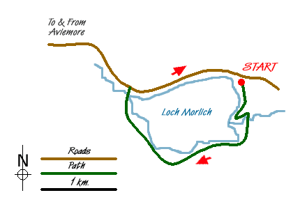
From Aviemore take the road leading to the mountain railway and ski centre. This road, which starts as the B970, leads into Rothiemurchus Forest. Continue through Inverdruie and within 3 miles you enter Glenmore Forest and the road runs along side Loch Morlich for about a mile. Take the car park signed Loch Morlich Watersports immediately after you pass the end of the Loch on the right hand side (Grid ref. NH972098).
After parking (small fee payable), leave the car park to the south through the forest passing the toilet block to your left with the waters edge 50 meters to your right. The noise coming off the Loch through the trees is striking as you make your way along the superb path laid out by the National Park Authority. Continue until you reach the outflow of the Abhainn Ruigh River. Bear left here for about 300 meters until you reach a footbridge. Cross the river here and turn right back towards the Loch. After a short while the path splits. Keep right here.
The going is now very straightforward as you walk towards the forestry commission access road. Bear right on the road but do take care, particularly with children, as the road can be in use by log trucks on weekdays as the logging industry is currently very active. Continue along for half an hour until a sign is reached to the right marked Loch Morlich Circular (Grid ref. NH959088). Take this and cross back into Rothiemurchus over a small footbridge. After a while the path meets the forestry commission track again, which leads you back to the main road.
Cross the bridge by Glenmore Lodge and walk along the road for a few meters until a way marker takes you back to the waters edge on your right. Here the views across the Loch to the mountain range are spectacular, particularly in winter, making it a worthy photo stop. Continue along passing through the lay-bys until you reach the sailing club. From here there is a faint path or alternatively walk along side the road on the grass. Shortly before the car park is reached, take the faint path down the bank leading onto the bright orange river sands. Walk along here and then turn left back into the car park from where you started. Looking across the loch you can think about what you have achieved in such a short space of time.
Messaging & Social Media
Message Walking Britain and follow the latest news.

Mountain Weather
Stay safe on the mountains with detailed weather forecasts - for iOS devices or for Android devices.