Loch Morlich circular (near Aviemore)
Cairngorms Walk
Nat Park - Cairngorms - Cairngorm North
County/Area - Highland
Author - Andy Smith
Length - 4.0 miles / 6.5 km Ascent - 200 feet / 61 metres
Time - 2 hours 10 minutes Grade - easy
Walk Route Description
Click image to visit gallery of 9 images.
This walk provides an easy but lengthy afternoon out for all the family enjoying some of the finest forest trails in the country. As the Cairngorms is one of Britain's newest national parks, there are numerous pathways and picnic spots all located in superb settings. Although this is a low level route, it is always worth checking the local weather forecast as Loch Morlich sits at the foot of the northern Cairngorm mountain range, which can have surprisingly sudden changes in weather.
From Aviemore take the road leading to the mountain railway and ski centre. This road, which starts as the B970, leads into Rothiemurchus Forest. Continue through Inverdruie and within 3 miles you enter Glenmore Forest and the road runs along side Loch Morlich for about a mile. Take the car park signed Loch Morlich Watersports immediately after you pass the end of the Loch on the right hand side (Grid ref. NH972098).
After parking (small fee payable), leave the car park to the south through the forest passing the toilet block to your left with the waters edge 50 meters to your right. The noise coming off the Loch through the trees is striking as you make your way along the superb path laid out by the National Park Authority. Continue until you reach the outflow of the Abhainn Ruigh River. Bear left here for about 300 meters until you reach a footbridge. Cross the river here and turn right back towards the Loch. After a short while the path splits. Keep right here.
The going is now very straightforward as you walk towards the forestry commission access road. Bear right on the road but do take care, particularly with children, as the road can be in use by log trucks on weekdays as the logging industry is currently very active. Continue along for half an hour until a sign is reached to the right marked Loch Morlich Circular (Grid ref. NH959088). Take this and cross back into Rothiemurchus over a small footbridge. After a while the path meets the forestry commission track again, which leads you back to the main road.
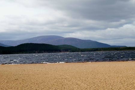
Cross the bridge by Glenmore Lodge and walk along the road for a few meters until a way marker takes you back to the waters edge on your right. Here the views across the Loch to the mountain range are spectacular, particularly in winter, making it a worthy photo stop. Continue along passing through the lay-bys until you reach the sailing club. From here there is a faint path or alternatively walk along side the road on the grass. Shortly before the car park is reached, take the faint path down the bank leading onto the bright orange river sands. Walk along here and then turn left back into the car park from where you started. Looking across the loch you can think about what you have achieved in such a short space of time.
Maps 

| Ordnance Survey Explorer OL57 | Sheet Map | 1:25k | BUY |
| Anquet OS Explorer OL57 | Digital Map | 1:25k | BUY |
| Ordnance Survey Digital Map Subscription | |||
| Latest Ordnance Survey Discounts | |||
Other walks nearby
| Walk 2412 | Craiggowrie & Creagan Gorm from Loch Morlich | mod/hard | 7.3 miles |
| Walk 2607 | Lairig Ghru & Chalamain Gap from Glenmore | mod/hard | 11.0 miles |
| Walk 3579 | Meall a'Bhuachaille & Ryvoan Bothy from Glenmore | moderate | 5.5 miles |
| Walk 3218 | Eag a' Chait gap Via Rothiemurchus Lodge from Glenmore | moderate | 8.2 miles |
| Walk 1020 | Glenmore to Linn of Dee via Lairig Ghru & Corrour | hard | 21.0 miles |
| Walk 1605 | Loch an Eilein & Rothiemurchus Forest from Loch Morlich | easy/mod | 10.0 miles |
| Walk 2421 | Braeriach via the Chalamain Gap | hard | 15.0 miles |
| Walk 1881 | Ben Macdui & Cairn Lochan from the Ski Centre | hard | 10.4 miles |
| Walk 2672 | Cairngorm Mountain via Coire an t-Sneachda | mod/hard | 6.0 miles |
| Walk 1390 | Cairn Lochan via the Fiacaill Buttress from Ski Centre | very hard | 5.7 miles |
Recommended Books & eBooks
Walking in Torridon
 This guidebook contains 52 day walks in Torridon, a remote and much-loved area of the Scottish Highlands. Based around Shieldaig and Slioch, the routes are split into 3 sections: easy walks, long and high level walks and mountain ascents over 2000ft including 9 Munros, and 5 outline suggestions for major ridge walks.
More information
Great Mountain Days in Scotland
 Inspirational guidebook to 50 challenging routes for mountaineers, scramblers, hillwalkers and fell runners, many long enough to backpack over 2 days, especially in winter (12 to 25 miles). A mix of classic routes and unsung gems across Scotland from Galloway to the Outer Hebrides in widely differing wild landscapes. With customised OS mapping.
More information
