Great Orme & Country Park from Llandudno
Conwy Walk
County/Area - Conwy
Author - Lou Johnson
Length - 7.0 miles / 11.4 km Ascent - 1200 feet / 364 metres
Time - 4 hours 40 minutes Grade - easy/mod
Walk Route Description
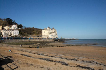
Click image to visit gallery of 12 images.
Despite the proximity of Llandudno, the Great Orme can offer respite from the crowds on the seafront. This prominent Limestone headland rises to 207 metres above sea level and offers some expansive views of Llandudno and the coast, Conway with its fine castle and the mountains of Snowdonia (Eryri).
The start for this walk is Prince Edward Square (grid ref SH781826) towards the western end of Llandudno's promenade. From here walk along North Parade (with the sea to your right) towards the entrance to the pier. Before reaching the pier, turn left following the signs to the Tram Station. Walk past the station and take the second small street on the right which leads you up to Cwlach Road. Turn left and continue through Haulfre Gardens to join the Invalids Walk, which is lined with benches donated by people that once enjoyed the view towards Conway and over Llandudno town.
You soon reach the start of a zig-zag path on your right. This is located just before a concrete shelter on the right and signed 'Summit Trail Zig-Zag'. The path climbs the steep hillside with the zig-zags making progress quite fast. Once on this trail stay on the main path and follow the clear signs and marker posts. The path levels for a short distance before climbing up a rocky step. The route continues in this fashion until sight of the summit comes in view. During the ascent a flock of wild goats were encountered. Do heed the warnings given on signs about feeding them.
You can take the direct route towards the trig point which marks the official summit of the Great Orme. From here walk the short distance to the summit station and the cafe/pub alongside. The onward route starts from the car park behind the summit tram station. To reach the path, walk into the car park and turn left and walk through the gap on the marked path. This follows a stone wall which is on your right. Continue to a wall corner and turn right along the wall. There are superb views to your left across to Conwy and the Carneddau mountains of Snowdonia (Eryri).
Reaching the end of the wall (grid ref. SH756836), turn right again. You will some evidence of the underlying limestone in this area. After about 300 metres bear half right (due north) following small paths towards the north coast of the headland. Quite soon you will reach a viewpoint offering a grand panorama along the north coast with rugged cliffs and the castellated walls of the lighthouse. You now need to rejoin the main path which has now become a track and this is followed alongside the wall as it heads south east in the general direction of the summit.
The track soon reaches a point where you have a bird's eye view of St Tudno's Church and cemetery far below you on the left. This is the next objective and is reached by either following the tarmac lane or cutting across the grassy path on the left.
Walk down the lane towards the Church. Almost opposite is a footpath sign. Follow this and the marker posts. At the first junction (grid ref. SH771835) take the left fork. This leads to cottages. Stay on the marked route and this soon takes you the top of the dry ski run and toboggan track. Two options are available at this point. Either follow the stepped path down towards Llandudno or alternatively bear left and follow a grassy path towards the cliff tops. Quite soon you will be rewarded with a superb view of the Pier and the whole of the front at Llandudno. To continue bear right and rejoin the concrete path. Do be careful if you have young children as there are some steep drops on this option.
Once on the main path through Happy Valley descend through some pleasant rock gardens towards the sea and town centre. The route is well signed. Joining a tarmac road, turn right. This takes you down past the Grand Hotel back to the start on the main promenade.
Maps 

| Ordnance Survey Explorer OL17 | Sheet Map | 1:25k | BUY |
| Anquet OS Explorer OL17 | Digital Map | 1:25k | BUY |
| Ordnance Survey Digital Map Subscription | |||
| Latest Ordnance Survey Discounts | |||
Other walks nearby
| Walk 1435 | Sychnant Pass, Alltwen, Penmaen-Bach, & Conwy Mountain | easy/mod | 3.0 miles |
| Walk 3604 | Foel Lus & Jubilee Path from Sychnant Pass | easy/mod | 5.9 miles |
| Walk 2497 | Druid Circle, Moelfre and Foel Lus from Penmaenmawr | easy/mod | 6.0 miles |
| Walk 3061 | Eastern Carneddau from near Rowen | mod/hard | 10.5 miles |
| Walk 2547 | Carnedd Llewelyn from near Rowen | mod/hard | 12.0 miles |
| Walk 2346 | Yr Orsedd ridge from near Bont Newydd | moderate | 4.8 miles |
| Walk 3020 | Aber Falls, Foel-fras & Drum | mod/hard | 9.0 miles |
| Walk 3021 | Northern Carneddau | mod/hard | 12.0 miles |
| Walk 1635 | Garnedd Uchaf & Llyn Eigiau | mod/hard | 9.0 miles |
| Walk 2542 | Foel Grach & Llyn Eigiau | moderate | 8.5 miles |
Recommended Books & eBooks
Snowdonia: 30 Low-level and easy walks - North
 Guidebook describing 30 walks in Snowdonia, Wales. Routes are mostly low level and on clear paths and showcase the region's beautiful scenery and rich history and culture. Part of a 2-volume set, this northern volume includes the Snowdon area, the Ogwen and Conwy Valleys, Betws-y-Coed, Beddgelert, Ffestiniog and the coast.
More information
Snowdonia: 30 Low-level and easy walks - South
 Guidebook describing 30 walks in Snowdonia, Wales. Routes are mostly low level and on clear paths and showcase the region's beautiful scenery and rich history and culture. Part of a 2-volume set, this southern volume includes Trawsfynydd, Bala, Dolgellau, Machynlleth, the Harlech Coast and the valleys of the Mawddach and Dyfi.
More information
