Walk 1940 - printer friendly version
Lea Valley from Enfield Lock to Bow Walk
Author - Barry Mackie
Length - 12.5 miles / 20.3 km
Ascent - 200 feet / 61 metres
Grade - easy/mod
Start - OS grid reference TQ371987
Lat 51.670352 + Long -0.018824131
Postcode EN3 6JN (approx. location only)
This is the last part of a 50mile / 80km trail that begins at the source of the River Lea, north of Luton, Bedfordshire. It then follows the Lea Valley into the heart of East London. The walk is along the towpath of the Lee Navigation, a "canalised" section of the River Lea. For this section, there is only one road to cross, and the walk is reasonably well waymarked, sometimes with the recognised white swan logo. From Walthamstow Marshes to the finish at Bow Locks, the walk "piggy backs" with other major routes and the signage is excellent.
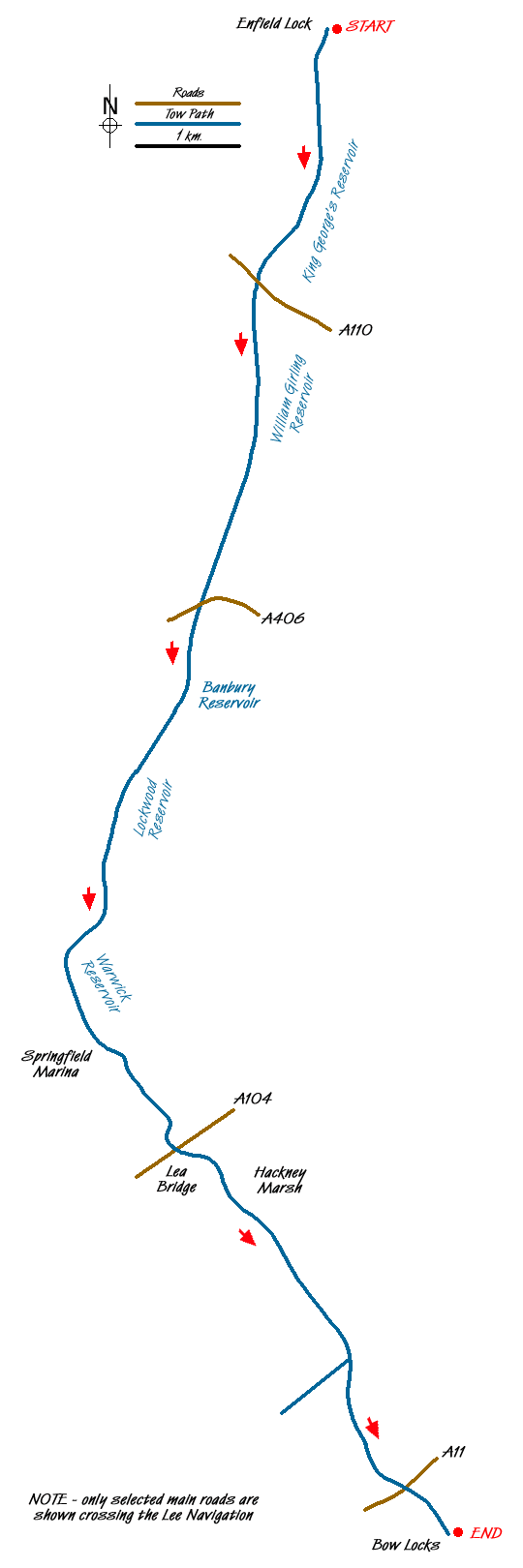
The start point is the west bank of the Lee Navigation, next to the Greyhound Pub in Ordnance Road, Enfield Lock (Grid ref TQ 371987). Alongside the towpath is an impressive waymarker, one of three like this on the walk. The complicated system of waterways that started further north at Hartham Common, continues with the Lee Navigation and the now resurgent River Lea effectively forming a "dual carriageway" as they make their respective ways to the River Thames.
Walk south on the path, with the canal on your left, to reach the lock (Enfield Lock). Cross the canal here continuing south and soon the raised grassy banks of the first of two massive reservoirs (King George's and William Girling) appear on your left. This remains the view for the next few miles. On the far bank of the canal is a varied mixture of housing, industrial and open space. With few walkers or cyclists about and no river traffic, this section can feel quite isolated.
Note- at the time of writing (2006) Picketts Lock was closed for refurbishment. Normally during the daytime you will see boats moving along the canal on this section.
Continue on the path, passing the Ponders End and Picketts Locks and the open area of Tottenham Marshes to reach Stonebridge Lock. Here you cross to the east bank with an outside picnic area and toilet facilities. From here, it's less than a mile to Tottenham Lock, and if this is your preferred finishing point, then the railway station is a five minute walk away.
The path now skirts around the Warwick Reservoir and then reaches Springfield Marina. Cross the footbridge over the canal and into Walthamstow Marshes, one of the last remaining wetlands in London. After leaving the marshes, the next point is Lea Bridge, which is a good place to come off the walk for some refreshments.
Almost immediately after leaving Lea Bridge, on your left is an entrance to the Middlesex Filter Beds. Just the name might be enough to make you curious, and the excellent information board will entice you to take a look. This nature reserve once had an important role in providing London's drinking water and it's well worth a visit. The main features for us were the effects that nature has as it regains control of a manmade structure, and also for the "mini Stonehenge" a few yards from the entrance.
A short distance further on, the path leads to the edge of Hackney Marsh, famous for having the largest concentration of football pitches (eighty seven) in the whole of Europe, some of which you will see from alongside the canal. With the reservoirs and marshes now behind you, both sides of the canal start to get more built up as the end of the walk draws near. The next point of interest is the Hertford Union Canal where it meets the Lee Navigation and looking along it, in the distance, are some high rise buildings, including the Swiss Re (The Gherkin) in the City of London.
Continue alongside the Lee to Old Ford Lock and here the view in the distance is dominated by Canary Wharf and its Tower, the highest building in Britain. At last you reach the only main road on this walk. Cross it by the roundabout and go straight on. A few yards later turn left into Global Approach to regain the bank of the canal to reach Three Mills, and some stunning views.
The River Lea, now tidal, emerges alongside the Lee Navigation; Canary Wharf is closer now and lit up by the late afternoon sunshine and nearer still, Bow Locks. The walk finishes at Bow Locks and is marked in some style with another of the huge Lea Valley Walk waymarkers, but the river and the canal keep going on their final, but separate journeys to the Thames.
Footnote - If you have stood on that concrete culvert some 50miles away at the source of the River Lea in Leagrave and seen the equivalent of a gently running tap, then you'll possibly stand here and marvel. We did.
Transport - As mentioned earlier, if you prefer a shorter walk, then come off at Tottenham Lock. To get back to the start it is a direct link from the rail station nearby back to the station at Enfield Lock and then a half mile bus ride to Ordnance Road. From Bow, Bromley-by-Bow underground station is close by. Take the tube to Liverpool Street and transfer to the rail link and then on to Enfield Lock rail station, again with a short bus ride to Ordnance Road.
Messaging & Social Media
Message Walking Britain and follow the latest news.

Mountain Weather
Stay safe on the mountains with detailed weather forecasts - for iOS devices or for Android devices.