Clifton Upon Teme Circular
Worcestershire Walk
County/Area - Worcestershire
Author - Lou Johnson
Length - 5.8 miles / 9.4 km Ascent - 700 feet / 212 metres
Time - 3 hours 40 minutes Grade - easy/mod
Maps 

| Ordnance Survey Explorer 204 | Sheet Map | 1:25k | BUY |
| Anquet OS Explorer 204 | Digital Map | 1:25k | BUY |
Walk Route Description
Click image to see photo description.
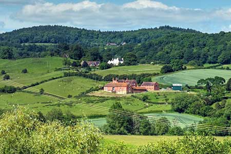
Clifton upon Teme is an attractive village lying west of the Teme Valley. The immediate area is a patchwork of pasture and woodland scattered across hills on either side the river. The route descends from Clifton Hill into the Teme Valley and then follows the river to Shelsey Beauchamp. Recrossing the river, the walk continues via Shelsey Walsh from where an ascent back to the start following the Shelsey Hill Climb route for some of the way.
The start is Clifton upon Teme (grid ref. SO714616) where limited on-street parking is available. After parking walk east along the B4204 to pass the green and The Lion Inn. Just before St. Kenelm's Church, turn left up a driveway and continue into a field and turn right keeping the hedge on your right to a stile. Entering the next field aim to the left of Church House Farm and follow a hedge (on your right). The path soon reaches another field where the path runs along side a hedge on your left. Continue ahead through a small wood. Leaving the trees go straight down the field towards a hedge. Reaching the hedge turn sharp right and ascend to a stile (grid ref. SO726614). Cross the stile, turn left along a bridleway and keep the hedge on your left. Continue across a field and then beside a wood on your left. The route enters the trees and exits into a field and a lane (grid ref. SO736611).
Turn right and then left along the B4204. Cross Ham Bridge over the River Teme and take the first footpath on the left by a fingerpost. The path initially runs beside the river to woodland where you ignore paths going right. After the woodland, the route drifts way from the river and leads to the church in Shelsey Beauchamp (grid ref. SO731629). Turn left and follow the road across ill Bridge and turn left (signed to Shelsey Walsh).
Approaching the village, turn left onto the first signed footpath by a house (grid ref. SO723631). Turn right in front of the Court House and then left at the next junction and follow the track uphill. Continue ahead to reach a pair of barns on the left of the track (Top Barn). Just before reaching a cattle grid (shortly after passing the barns), turn right along the hedge and head uphill. After 200 metres and two stiles, turn left with hedge on your left. Almost immediately turn right on a clear path straight across a field. Continue ahead to reach the B4204 in Clifton upon Teme and return to the start.
Other walks nearby
| Walk 3240 | Woodbury and Abberley Hills from Great Witley | easy/mod | 5.3 miles |
| Walk 1099 | Abberley Hills - Worcestershire Way Circular | easy/mod | 4.0 miles |
| Walk 3662 | Abberley Circular | easy/mod | 4.8 miles |
| Walk 2142 | Severn Valley from Grimley | easy | 5.0 miles |
| Walk 1830 | Ombersley, the Droitwich Canal, Salwarpe & the Severn | easy/mod | 11.0 miles |
| Walk 3442 | Haws Hill from Tenbury Wells | easy/mod | 6.6 miles |
| Walk 2248 | Wimperhill Wood and Longdon Orchard, Wyre Forest | easy | 4.0 miles |
| Walk 2483 | Cradley Circular | easy/mod | 6.0 miles |
| Walk 3217 | Bewdley and Snuffmill Dingle | easy | 5.0 miles |
| Walk 1556 | The Malverns - end to end | hard | 10.0 miles |
Recommended Books & eBooks
No suggestions for this area.Messaging & Social Media
Message Walking Britain and follow the latest news.

Mountain Weather
Stay safe on the mountains with detailed weather forecasts - for iOS devices or for Android devices.