Abberley Hills - Worcestershire Way Circular
Worcestershire Walk
County/Area - Worcestershire
Author - Peter Lane
Length - 4.0 miles / 6.5 km Ascent - 900 feet / 273 metres
Time - 2 hours 50 minutes Grade - easy/mod
Walk Route Description
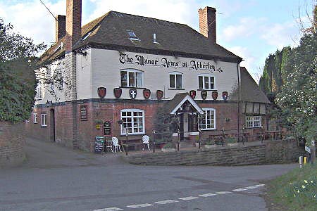
Click image to visit gallery of 9 images.
A straightforward short walk that largely follows one of the official Worcestershire Way circular routes. The highlights of this walk are the Norman church in the village of Abberley, the expanse of the Abberley ridge, the views out to the clock tower at Abberley School and quite possibly the Manor Arms pub! There are some great views across Worcestershire, but the ridge walk itself is largely wooded and secluded.
The walk commences at the Norman Church opposite the Manor Arms pub in Abberley village, grid reference SO754678. There is some limited parking here, on the roadside or in the pub car park (assuming you become a patron). Take a few minutes to explore the partly ruined, partly intact Norman Church of St Michael's either now or at the end of the walk.
Drop down the hill from the pub, past the first footpath signed on the left, taking the second path at a fingerpost. Follow a stream for a bit and continue along a path down a private drive, past a house and into a field. The way is well sign-posted. Go through a metal gate where signed and emerge back onto the lane. Approximately 200 metres further up the lane turn right down the Worcestershire Way proper, just before Netherton House. This path drops to an ornamental pond and then rises to meet a lane at the foot of the Abberley Hills ridge. Turn left along the lane for about 100 metres.
On the right a very steep set of wooden steps climbs the bank up a public footpath that rises steeply up the side of the hill. Take this narrow and steep hill as it rises through rough woodland. Follow the obvious path along the crest of the ridge. There are steep drops to the left and the right at various times, but the views are largely obscured by trees. The winter may be a better time to appreciate the views when the trees are bare. Eventually the path does open out to a view point that looks South to the clock tower at Abberley Hall and Woodbury Hill (See walk 3240). Then, after passing the lovingly adopted, whitewashed trig point, descend through woods to a lane. Turn right down the lane for just over 100 metres and then turn left down a footpath with many steps.
Descend the steps, enter a field and then pass through a number of gates and then return to the village of Abberley down a lane. Now there is another opportunity to visit either the Norman church or the pub; the choice is yours!
Maps 

| Ordnance Survey Explorer 204 | Sheet Map | 1:25k | BUY |
| Anquet OS Explorer 204 | Digital Map | 1:25k | BUY |
| Ordnance Survey Digital Map Subscription | |||
| Latest Ordnance Survey Discounts | |||
Other walks nearby
| Walk 3662 | Abberley Circular | easy/mod | 4.8 miles |
| Walk 3240 | Woodbury and Abberley Hills from Great Witley | easy/mod | 5.3 miles |
| Walk 1969 | Clifton Upon Teme Circular | easy/mod | 5.8 miles |
| Walk 3217 | Bewdley and Snuffmill Dingle | easy | 5.0 miles |
| Walk 2248 | Wimperhill Wood and Longdon Orchard, Wyre Forest | easy | 4.0 miles |
| Walk 2131 | Wyre Forest National Nature Reserve, Bewdley | easy | 3.3 miles |
| Walk 2288 | Pound Green and Dowles Brook from Hawkbatch | easy | 5.0 miles |
| Walk 1830 | Ombersley, the Droitwich Canal, Salwarpe & the Severn | easy/mod | 11.0 miles |
| Walk 2142 | Severn Valley from Grimley | easy | 5.0 miles |
| Walk 2466 | The Severn Valley from Trimpley Reservoir | easy | 6.0 miles |
