Walk 1972 - printer friendly version
Foxton Locks & Laughton from Saddington Walk
Author - Lou Johnson
Length - 7.9 miles / 12.8 km
Ascent - 600 feet / 182 metres
Grade - easy/mod
Start - OS grid reference SP659919
Lat 52.5210040 + Long -1.0301970
Postcode LE8 0QA (approx. location only)
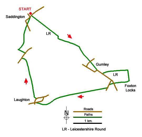
This walk from Saddington explores the countryside east of the village. The route follows the Leicestershire Round long distance path across undulating country through Gumley to Foxton Locks on the Grand Union Canal. The return route uses paths through Laughton back to the start.
The walk begins in Saddington where on street parking is available close to the start (grid ref. SP659919) at the junction of Main Street and Bakehouse Lane. Take the walled path in the parking area through a metal kissing gate. The path heads southeast downhill across fields into a broad valley with views to Saddington Reservoir. Cross four footbridges and you start the climb out of the valley. Maintain direction uphill across two fields turning sharp right at the top of the second field. Keep the hedge on your left and then fork left straight across a field to a gate (grid ref. SP670911).
Continue ahead with the hedge on your left ad then bear half-right and walk with a small copse on your right to a gate. Ignore the footpath on the left and continue uphill across three fields to a stile and Debdale Lane. Turn left and immediately left onto a signed path through a metal kissing gate. Continue ahead through the churchyard onto Main Street in Gumley (grid ref. SP 680901).
Continue along Main Street away from the church and after 250 metres turn left onto a signed footpath by a green telephone box. After 100 metres fork right and continue across a farm access road. Maintain direction across more fields to reach a footbridge over the Grand Union Canal. Cross the canal and turn right to Foxton Locks where the heritage centre and the locks are worth exploring.
To start the return to Saddington, cross bridge 61 by the Foxton Locks Inn and walk west along a track into a field. Maintain direction across this field along a grassy track to Foxton Road (grid ref. SP686896). Cross the lane and a field to another lane. Turn left along the lane for 1509 metres and take the signed bridleway on the right. The route follows a clear track. Follow signs as route passes to the right of Gumley Lodge. Continue across a long field to a stile keeping parallel to the filed boundary on your left. Continue ahead to another stile followed by a gate. Cross a small footbridge and continue ahead to a lane.
Cross the lane to the footpath opposite and walk half-right across towards some barns and a gate to join Main Street in Laughton. Turn left and then first right. Continue to a triangle of grass on the left and turn left along a lane signed unsuitable for motor vehicles. After 500 metres, turn left at a junction and follow the clear track for a kilometre to Mowsley Road (grid ref. SP656905). Turn right and after 300 metres turn left onto a signed footpath. Continue down to Mowsley Brook and turn right. Keeping the brook on your left continue to, and cross footbridge. Continue ahead with hedge on your left across two fields to re-join Mowsley Road. Cross the road to the signed track opposite. Pass the Church on your left and re-join Main Street in Saddington. The start is a short walk along on the right.
Messaging & Social Media
Message Walking Britain and follow the latest news.

Mountain Weather
Stay safe on the mountains with detailed weather forecasts - for iOS devices or for Android devices.