Walk 1975 - printer friendly version
Erme Mouth Walk
Author - Lou Johnson
Length - 9.0 miles / 14.6 km
Ascent - 1500 feet / 455 metres
Grade - moderate
Start - OS grid reference SX651442
Lat 50.2823060 + Long -3.8947825
Postcode TQ7 4AS (approx. location only)
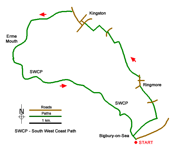
This South Devon walk starts from Bigbury-on-Sea and turns inland to cross rolling countryside through the villages of Ringmore and Kingston to descend through Furzedown Wood to reach the Erme Estuary. From here the walk follows the South West Coast Path along a beautiful section of coastline back to the start. Depending on tides, an optional visit to Burgh Island can be undertaken.
The start is the main pay and display car park on the sea front at Bigbury-on-Sea (grid ref. SX651442). After parking walk to the inland side of the car park and locate a three-way fingerpost by recycling bins. Follow the SWCP to the River Erme up to road along the front (Marine Drive). Cross Marine Drive and take Parker Road opposite. Walk to the top of the hill to join a signed footpath (grid ref. SX653446). Before continuing enjoy the view back to Burgh Island.
The path (later a track) keeps to the right-hand side of three fields to reach a junction. Turn left downhill into a valley and climb up to a lane. Cross the lane and take the footpath opposite. The path drops into a valley before climbing up across fields to join a track that leads to a lane in the village of Ringmore (grid ref. SX653458). Keep ahead passing between thatched cottages Bear right to pass to the right of the church and take the first footpath on the left (grid ref. SX653461).
The path crosses pastures and descends into a wooded valley. Follow the path as it climbs up through the trees to reach open fields to reach a track (grid ref. SX645471). Turn right along the track. When the track bends left continue ahead across one field to a lane. Turn left and the take the first path on the right across a stile. The path crosses a field (hedge right). Entering the next field follow the path around the right-hand hedge to reach the far left-hand corner. Walk half-right across the next fields and continue to a lane on the outskirts of Kingston (grid ref. SX637476).
Reaching a T-junction, turn right and then take the first lane on the left (signed to Dolphin Inn). Pass the Inn and turn left past the church. Turn right at the next junction (signed Wonwell Beach). Continue along the lane for 450 metres and turn left onto a signed footpath to Wonwell Beach. Follow the path down through Furzedown Wood to reach a lane (grid ref. SX620478). Turn left along the lane following the South West Coast Path. Past Erme Mouth and join the cliff top coast path. Like many coast paths the route is undulating with many ups and downs. However, the beautiful coastal scenery more than compensates for the effort. The route briefly joins a road at Challabrough before the coast path continues back to Bigbury-on-Sea.
If time and tides permit, a worthwhile option is to cross the causeway to Burgh Island where a number of paths allow you to explore the island. In addition, there is an excellent view west along the section of coast just walked.
Messaging & Social Media
Message Walking Britain and follow the latest news.

Mountain Weather
Stay safe on the mountains with detailed weather forecasts - for iOS devices or for Android devices.