Erme Mouth from Bigbury-on-Sea
Devon Walk
County/Area - Devon
Author - Lou Johnson
Length - 9.0 miles / 14.6 km Ascent - 1500 feet / 455 metres
Time - 6 hours 0 minutes Grade - moderate
Walk Route Description
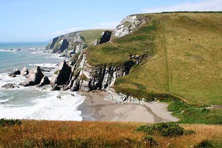
Click image to see photo description.
This South Devon walk starts from Bigbury-on-Sea and turns inland to cross rolling countryside through the villages of Ringmore and Kingston to descend through Furzedown Wood to reach the Erme Estuary. From here the walk follows the South West Coast Path along a beautiful section of coastline back to the start. Depending on tides, an optional visit to Burgh Island can be undertaken.
The start is the main pay and display car park on the sea front at Bigbury-on-Sea (grid ref. SX651442). After parking walk to the inland side of the car park and locate a three-way fingerpost by recycling bins. Follow the SWCP to the River Erme up to road along the front (Marine Drive). Cross Marine Drive and take Parker Road opposite. Walk to the top of the hill to join a signed footpath (grid ref. SX653446). Before continuing enjoy the view back to Burgh Island.
The path (later a track) keeps to the right-hand side of three fields to reach a junction. Turn left downhill into a valley and climb up to a lane. Cross the lane and take the footpath opposite. The path drops into a valley before climbing up across fields to join a track that leads to a lane in the village of Ringmore (grid ref. SX653458). Keep ahead passing between thatched cottages Bear right to pass to the right of the church and take the first footpath on the left (grid ref. SX653461).
The path crosses pastures and descends into a wooded valley. Follow the path as it climbs up through the trees to reach open fields to reach a track (grid ref. SX645471). Turn right along the track. When the track bends left continue ahead across one field to a lane. Turn left and the take the first path on the right across a stile. The path crosses a field (hedge right). Entering the next field follow the path around the right-hand hedge to reach the far left-hand corner. Walk half-right across the next fields and continue to a lane on the outskirts of Kingston (grid ref. SX637476).
Reaching a T-junction, turn right and then take the first lane on the left (signed to Dolphin Inn). Pass the Inn and turn left past the church. Turn right at the next junction (signed Wonwell Beach). Continue along the lane for 450 metres and turn left onto a signed footpath to Wonwell Beach. Follow the path down through Furzedown Wood to reach a lane (grid ref. SX620478). Turn left along the lane following the South West Coast Path. Past Erme Mouth and join the cliff top coast path. Like many coast paths the route is undulating with many ups and downs. However, the beautiful coastal scenery more than compensates for the effort. The route briefly joins a road at Challabrough before the coast path continues back to Bigbury-on-Sea.
If time and tides permit, a worthwhile option is to cross the causeway to Burgh Island where a number of paths allow you to explore the island. In addition, there is an excellent view west along the section of coast just walked.
Maps 

| Ordnance Survey Explorer OL20 | Sheet Map | 1:25k | BUY |
| Anquet OS Explorer OL20 | Digital Map | 1:25k | BUY |
| Ordnance Survey Digital Map Subscription | |||
| Latest Ordnance Survey Discounts | |||
Other walks nearby
| Walk 3041 | Thurlestone circular | easy | 4.0 miles |
| Walk 2461 | Warren Point & Bolt Tail from Bantham | moderate | 9.0 miles |
| Walk 3432 | Salcombe to Thurlestone | mod/hard | 11.0 miles |
| Walk 3276 | Gara Point & Stoke Point from Noss Mayo | easy/mod | 7.0 miles |
| Walk 2012 | Wembury Bay & St Peter's Church from Noss Mayo | easy/mod | 6.0 miles |
| Walk 1866 | East Prawle & Prawle Point | easy/mod | 4.1 miles |
| Walk 2474 | East Prawle Coast Circular | easy/mod | 5.6 miles |
| Walk 3387 | Upper Erme Valley & Ugborough Moor | moderate | 9.3 miles |
| Walk 3431 | Beeson to Salcombe | mod/hard | 12.0 miles |
| Walk 2018 | Saltram Park & Hardwick Wood, Plymouth | easy | 5.0 miles |
Recommended Books & eBooks
South West Coast Path Map Booklet - St Ives to Plymouth
 Map of part of the southern section of the 630 mile (1014km) South West Coast Path National Trail. Covers the trail from St Ives to Plymouth along the west Cornwall and Devon coastline. This convenient and compact booklet of Ordnance Survey 1:25,000 maps shows the route, providing all of the mapping you need to walk the trail in either direction.
More information
The South West Coast Path
 Guidebook to walking the entire South West Coast Path National Trail. The route runs for 630 miles from Minehead to Poole along the north Devon, Cornish, south Devon and Dorset coastline. Divided into 45 stages, this long-distance coastal trek could be completed within 4 weeks, or walked in sections. Guide includes maps and essential information.
More information
