Walk 1976 - printer friendly version
Noar Hill from Selborne Walk
Author - Lou Johnson
Length - 5.0 miles / 8.1 km
Ascent - 600 feet / 182 metres
Grade - easy/mod
Start - OS grid reference SU742335
Lat 51.0960170 + Long -0.9417695
Postcode GU34 3JU (approx. location only)
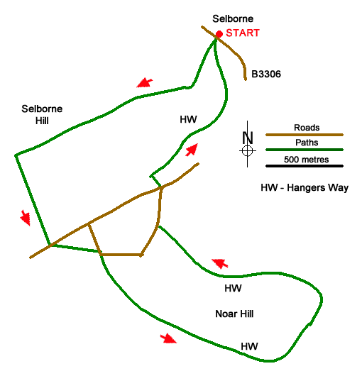
This Hampshire walk from Selborne explores a rolling landscape with a patchwork of woodland and farmland. The route starts by following the zigzag path which provides some excellent views across the village. The walk continues across Selborne Common before crossing a broad valley onto Noar Hill. The route follows a section of the Hangers Way around the hill and back to Selborne.
The walk starts from the Selborne village car park (grid ref. SU742335) on the south side of the B3306 through the village. After parking take the signed zig-zag path which climbs steeply onto Selborne Common. Reaching the ridge turn right and follow the main path across the common. Partially wooded with grassy open spaces you soon reach the end of the common (grid ref. SU729328). Turn left and follow Green Lane down to a road where you take the path opposite. Walk half-left across the field to a lane. Turn right and take the footpath into trees.
Almost immediately turn right off the lane top join a bridleway. The way ahead soon leaves the trees and reaches another lane (grid ref. SU736318). Go straight across and follow the path with a hedge on your left to the end of the field. The path then crosses a smaller field to reach a junction of paths. Maintain direction at the junction and join Hangers Way which will be followed back to Selborne. The path contours across the slopes of Noar Hill through woodland curving left to descend to High Common where there are open grassy areas.
Continue along Hangers Way down to a lane (grid ref. SU738323). Turn right and continue to a T-junction where you take the path opposite over a stile. At the end of the field turn right and keeping Homestead Farm on your right continue ahead keeping to the right-hand side of fields to join a lane. Continue straight ahead along the lane back to the start of the walk in Selborne.
Messaging & Social Media
Message Walking Britain and follow the latest news.

Mountain Weather
Stay safe on the mountains with detailed weather forecasts - for iOS devices or for Android devices.