Walk 1997 - printer friendly version
St. David's & Coast Path Circular Walk
Author - Lou Johnson
Length - 9.7 miles / 15.8 km
Ascent - 1000 feet / 303 metres
Grade - moderate
Start - OS grid reference SM753253
Lat 51.8808680 + Long -5.2661702
Postcode SA62 6SP (approx. location only)
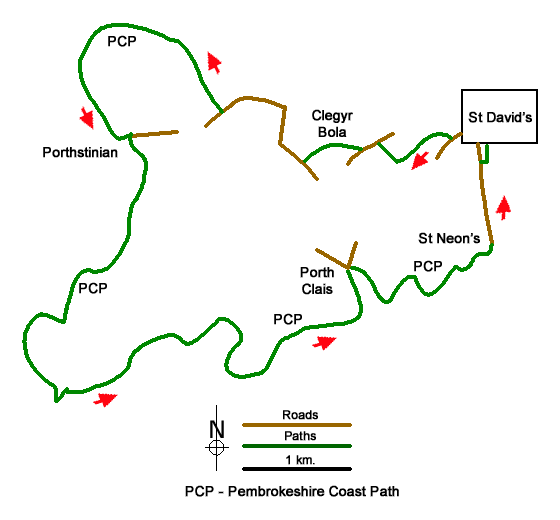
This Pembrokeshire walk from St David's explores the coast path around the peninsula lying to the west of the Cathedral city. The route follows lanes, tracks and paths including a section of the Pembrokeshire Coast Path. The coastal section of the walk is full of interest including St David's Head and Ramsey Island. If time allows a visit to the Cathedral and associated buildings is very rewarding.
The start is the War memorial in the city centre (grid ref. SM753253). A number of parking options can be found nearby. Walk west along Goat Street (signed to Porth Clais and St Justinians). At the first fork, bear left to continue along Goat Street. At the next junction fork right (signed to Porth Clais) and walk along Catherine Street to Ramsey Gardens on the left. Turn right at the fingerpost onto a bridleway. Follow the track as it loops left and then bends right to reach a road (grid ref. SM743252).
Turn left and after 200 metres turn right onto a tarmac drive (with adjacent fingerpost). Follow the track past Clegyr-Boia farm to a road (grid ref. SM737250). Bear right and follow the road continuing to a T-junction. Turn left and follow the road for 500 metres ignoring a lane off to the right. Turn right along a tarmac drive towards Pencarnan (by a bus stop on the right). Where the drive turns left into a caravan site, keep ahead along a track soon veering left off the track along a path that leads to the coast path (grid ref. SM727260).
Turn left along the Pembrokeshire Coast path. Continue along the coast path for just over ten kilometres. The route takes you through St Justinians, passes Ramsey Island, through Porth Clais with its small harbour and onto a chapel at St Nons. Turn inland at the three-way fingerpost (grid ref. SM752243). Pass the chapel and continue to join a lane. The lane eventually leads into Goat Street which can be followed into St David's. Alternatively, turn right (just past a hotel on the left) onto a bridleway (grid ref. SM751250). After a few metres turn left and follow the clear track back to the city centre.
Messaging & Social Media
Message Walking Britain and follow the latest news.

Mountain Weather
Stay safe on the mountains with detailed weather forecasts - for iOS devices or for Android devices.