St. David's & Coast Path Circular
Pembrokeshire Coast Walk
Nat Park - Pembrokeshire Coast
County/Area - Pembrokeshire
Author - Lou Johnson
Length - 9.7 miles / 15.8 km Ascent - 1000 feet / 303 metres
Time - 5 hours 50 minutes Grade - moderate
Walk Route Description
Click image to see photo description.
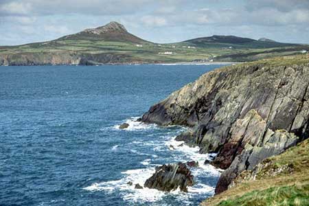
This Pembrokeshire walk from St David's explores the coast path around the peninsula lying to the west of the Cathedral city. The route follows lanes, tracks and paths including a section of the Pembrokeshire Coast Path. The coastal section of the walk is full of interest including St David's Head and Ramsey Island. If time allows a visit to the Cathedral and associated buildings is very rewarding.
The start is the War memorial in the city centre (grid ref. SM753253). A number of parking options can be found nearby. Walk west along Goat Street (signed to Porth Clais and St Justinians). At the first fork, bear left to continue along Goat Street. At the next junction fork right (signed to Porth Clais) and walk along Catherine Street to Ramsey Gardens on the left. Turn right at the fingerpost onto a bridleway. Follow the track as it loops left and then bends right to reach a road (grid ref. SM743252).
Turn left and after 200 metres turn right onto a tarmac drive (with adjacent fingerpost). Follow the track past Clegyr-Boia farm to a road (grid ref. SM737250). Bear right and follow the road continuing to a T-junction. Turn left and follow the road for 500 metres ignoring a lane off to the right. Turn right along a tarmac drive towards Pencarnan (by a bus stop on the right). Where the drive turns left into a caravan site, keep ahead along a track soon veering left off the track along a path that leads to the coast path (grid ref. SM727260).
Turn left along the Pembrokeshire Coast path. Continue along the coast path for just over ten kilometres. The route takes you through St Justinians, passes Ramsey Island, through Porth Clais with its small harbour and onto a chapel at St Nons. Turn inland at the three-way fingerpost (grid ref. SM752243). Pass the chapel and continue to join a lane. The lane eventually leads into Goat Street which can be followed into St David's. Alternatively, turn right (just past a hotel on the left) onto a bridleway (grid ref. SM751250). After a few metres turn left and follow the clear track back to the city centre.
Maps 

| Ordnance Survey Explorer OL35 | Sheet Map | 1:25k | BUY |
| Anquet OS Explorer OL35 | Digital Map | 1:25k | BUY |
| Ordnance Survey Digital Map Subscription | |||
| Latest Ordnance Survey Discounts | |||
Other walks nearby
| Walk 1210 | Porth Clais & St Justinian's | easy/mod | 5.5 miles |
| Walk 2057 | St. David's Head & Carn Llidi | easy/mod | 4.5 miles |
| Walk 3483 | Penberry & St Davids Head from Whitesands Bay | moderate | 9.0 miles |
| Walk 2056 | Pointz Castle from Solva | easy/mod | 5.5 miles |
| Walk 3476 | Porthgain & Blue Lagoon from Abereiddy | easy/mod | 6.5 miles |
| Walk 3477 | Porthgain, Abereiddi Bay & Blue Lagoon | easy | 3.7 miles |
| Walk 1434 | Abercastle & Trefin Circular | moderate | 7.5 miles |
| Walk 2485 | Broad Haven & Druidston Circular | easy/mod | 4.9 miles |
| Walk 3473 | Marloes Peninsular Circular | easy/mod | 7.0 miles |
| Walk 3362 | Marloes Sands Circular | easy | 4.5 miles |
Recommended Books & eBooks
The Wales Coast Path
 A single guidebook to walking the whole Wales Coast Path - 1400km (870 miles) the length of Wales from Chester to Chepstow, including Anglesey, described in 57 stages. The route passes through the Snowdonia and Pembrokeshire National Parks and many AONBs and can be linked with the Offa's Dyke Path for a complete circuit of Wales.
More information
