Cross Gate to Nuns Cross via Leather Tor
Dartmoor Walk
Nat Park - Dartmoor
County/Area - Devon
Author - John Paterson
Length - 8.0 miles / 13 km Ascent - 875 feet / 265 metres
Time - 4 hours 50 minutes Grade - moderate
Walk Route Description
Click image to visit gallery of 6 images.
This walk on the high moor has some stretches where walking is by compass bearing with no path visible and it must be stressed that a map and compass (and the ability to use them) are essential. The walk should not be started in thick mist - although the return from Nuns Cross is on good paths and will cause no problems if the mist descends at that point.
Park on the track alongside Devonport Leat at Cross Gate (Grid ref: SX563695) which can easily be reached from the B3212 Yelverton to Princetown road by turning right on to a minor road just over half a mile north east of the Burrator Inn at Douseland. There are parking spaces for 4 cars at the entrance to the track but if these are full, drive along the track to reach a small quarry after 50 yards.
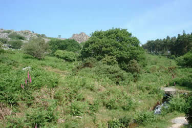
Head east along the track. After a few hundred yards a granite footbridge will be seen spanning Devonport leat - built to supply water to Plymouth many years ago. Cross the footbridge and continue on the south side of the leat for a few hundred yards until a gate can be seen ahead where the leat enters a wood. 50 yards before the gate (at a point marked "blowing house" on the 2.5 inch OS map) cross to the north side of the leat over a footbridge and head north up the bracken slope towards the rocks which lie to the left of Leather Tor (which can be seen on the skyline - see first picture above) The bracken slope gives way to a field of granite boulders which must be negotiated with care. The skyline rocks are soon reached and the view opens up to show Leather Tor with Sharpitor half a mile further on. Leather Tor has a rocky crest 150 yards long and about 50 feet above the moor (excellent views of Burrator). It is not difficult but, if you don't have a head for heights, pass to the left of the crest and head directly for Sharpitor which is reached in a few minutes.
From Sharpitor head north east to skirt Stanlake Plantation south of the B3212. Keep close to the woodland edge as it bends round to the east until you meet the leat again where it leaves the wood (Grid ref: SX569708). Turn left and follow the leat NNE until you reach an aqueduct which carries the leat over the river Meavy. Do not cross the aqueduct but carry on NNE up the Meavy valley until you cross the stream to reach a series of "stone rows" which are marked on the map. Some of Dartmoor's neolithic stone rows run for miles but these run for only a hundred yards or so. At the top of the rows, Hart Tor can be seen quarter of a mile away to the north east (see picture). Head for the tor over pathless terrain. On reaching Hart Tor, take the clear path (not shown on map) heading SSE to Cramber Tor. From the Tor a faint track leads due east to a trig point (marked 445 metres on map). At the trig point the path disappears but continue heading due east downhill until you meet the main track from Princetown to Nuns Cross. In good visibility this track can be seen as a white scar for miles as it is composed of granite chippings. Once the track is reached turn right and follow it as it runs straight as an arrow to Nuns Cross.
The easiest way to leave Nuns Cross is to head back north along the track to Princetown for about quarter of a mile until a very clear "crossroads" is reached. Turn left at the crossroads and follow the track down to meat the leat again at "Older Bridge". Cross the bridge and leave the leat behind as you follow the track in a westerly direction down the valley for one and a half miles until the track reaches Raddick Plantation. The track runs alongside the plantation until a fork is reached after half a mile. Take the right fork into the wood (signposted to Leather Tor Farm). Keep going downhill in the wood avoiding side tracks until Leather Tor Bridge is reached (marked on OS map) where the track again forks. Take the right fork over the bridge (signposted Cross Gate and County Road). After a few hundred yards an intriguing cave is seen on the right - probably an old mine working. Soon after the cave another signpost at a fork gives the choice of routes to Devonport Leat or Cross Gate. Either route will get you back to the start but the Cross Gate route is quickest and you will reach the start in 5 minutes.
Maps 

| Ordnance Survey Explorer OL28 | Sheet Map | 1:25k | BUY |
| Anquet OS Explorer OL28 | Digital Map | 1:25k | BUY |
| Ordnance Survey Digital Map Subscription | |||
| Latest Ordnance Survey Discounts | |||
Other walks nearby
| Walk 1083 | Eylesbarrow & Sheeps Tor | moderate | 8.0 miles |
| Walk 1642 | Burrator Reservoir from Yelverton | easy/mod | 8.5 miles |
| Walk 3671 | Nun's Cross & Peat Cot from Princetown | easy/mod | 7.0 miles |
| Walk 2015 | The Meavy & Plym valleys from Shaugh Bridge | moderate | 6.0 miles |
| Walk 2013 | The Plym Valley | easy | 5.0 miles |
| Walk 3463 | Sharp Tor, Corndon Tor & Yar Tor Circular | easy/mod | 3.4 miles |
| Walk 3201 | Bellever Tor & Postbridge | easy/mod | 5.5 miles |
| Walk 3202 | Postbridge & Challacombe Down from Bellever | moderate | 9.8 miles |
| Walk 2838 | Laughing Tors | easy | 3.5 miles |
| Walk 3387 | Upper Erme Valley & Ugborough Moor | moderate | 9.3 miles |
