Bellever Tor & Postbridge from Bellever
Dartmoor Walk
Nat Park - Dartmoor
County/Area - Devon
Author - Martyn Hanks
Length - 5.5 miles / 8.9 km Ascent - 600 feet / 182 metres
Time - 3 hours 20 minutes Grade - easy/mod
Walk Route Description
Click image to see photo description.
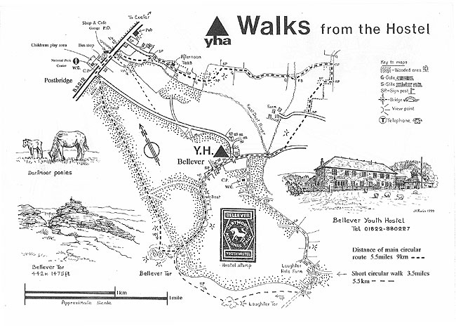
This Dartmoor starts from the small parking area just to the south of Bellever (grid ref. SX665771) a hamlet located south of Postbridge. The route visits Bellever Tor where there are some fine views over Dartmoor and then continues to Postbridge with its ancient clapper bridge. The return to the start initially follows a bridleway towards the hamlet of Pizwell before cutting across country back to the start.
From the parking area walk north along the track into Bellever. Turn left along the road in front of the Youth Hostel (which should be on your right). When the tarmac ends continue ahead on a track for just over 200 metres to a junction of paths (grid ref. SX651772) with an area of felled forestry ahead. Turn left here with a plantation on your left and continue along this track for about one kilometre to reach another junction with a track coming in from the right (grid ref. SX647764). Bear left here and almost immediately right onto a path that soon enters moorland. Continue on the rising path to the summit of Bellever Tor and enjoy the view.
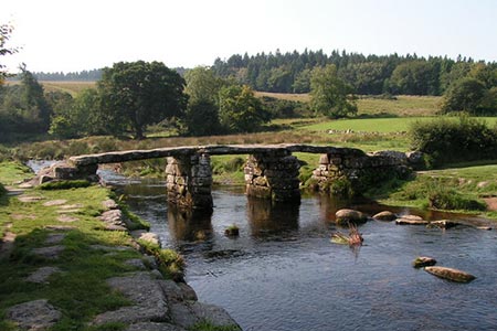
Leave the summit by taking the path heading north. This path crosses the remains of ancient settlements and leads to a gate at grid ref. SX646770. Join the wide track heading north and follow this just over a mile to reach the B3212 on the western edge of Postbridge. Turn right along the main road and view the old Clapper Bridge. Cross the clapper bridge and walk east along the main road for short distance to take the first bridleway on the right (grid ref. SX648789).
Follow this bridleway (passing the entrance to a hotel on your left) which initially parallels the East Dart River which is over to your right. Reaching Open Country (at grid ref. SX652785) the grassy path continues ahead and then bends to the left and right to join a track (grid ref. SX659784). Continue along this track as it bends sharp left and then sharp right to cross a stream over a footbridge (grid ref. SX663782). 300 metres after the footbridge (at grid ref. SX666782) and well before reaching the Hamlet of Pizwell, turn right down an enclosed track.
Stay on the track when it turns sharp right and then enters a field. Go half left across the field to follow another enclosed track to another track (grid ref. SX664778). Cross the track and head across rough grassland generally heading southwest to join a tarmac lane (grid ref. SX661774). Turn right along the lane, cross Bellever Bridge (with a clapper bridge to your left) and continue along the lane into Bellever. 200 metres after Bellever Bridge turn left down the access track to the parking area.
This walk is one of many routes prepared by Martyn Hanks for Youth Hostellers. The routes were drawn in a 'Wainwright' style and provided annotated maps offering additional information for walkers. Prepared before the days of GPS they were an invaluable resource and Walking Britain is happy to ensure that these walks remain in the public domain.
Maps 

| Ordnance Survey Explorer OL28 | Sheet Map | 1:25k | BUY |
| Anquet OS Explorer OL28 | Digital Map | 1:25k | BUY |
| Ordnance Survey Digital Map Subscription | |||
| Latest Ordnance Survey Discounts | |||
Other walks nearby
| Walk 3462 | Corndon Tor & Yar Tor Circular | easy/mod | 4.3 miles |
| Walk 3463 | Sharp Tor, Corndon Tor & Yar Tor Circular | easy/mod | 3.4 miles |
| Walk 1772 | Hurston, Lettaford & Two Moors Way | moderate | 8.6 miles |
| Walk 3757 | Buckland in the Moor Circular | easy/mod | 6.3 miles |
| Walk 3458 | Sharrah Pool from New Bridge | easy | 3.4 miles |
| Walk 3460 | Dr Blackall's Drive & Ponsworthy | easy/mod | 6.8 miles |
| Walk 3671 | Nun's Cross & Peat Cot from Princetown | easy/mod | 7.0 miles |
| Walk 1260 | Haytor Rocks & Hound Tor from Saddle Tor | moderate | 7.5 miles |
| Walk 1657 | Huntingdon Warren & Lud Gate from Scorriton | moderate | 7.0 miles |
| Walk 1083 | Eylesbarrow & Sheeps Tor | moderate | 8.0 miles |
