Great How, a short ascent above Thirlmere
Lake District Walk
Nat Park - Lake District - Lake District Central Fells
County/Area - Cumbria
Author - John Paterson
Length - 2.0 miles / 3.3 km Ascent - 600 feet / 182 metres
Time - 1 hours 40 minutes Grade - easy
Walk Route Description
Click image to visit gallery of 6 images.
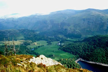
Great How is a thickly wooded hill and the trees reach above the summit cairn. However, only 50 yards down from the summit is a viewpoint with stunning views which make the walk well worth doing on the first or last day of a holiday or on one of those days when foul weather clears late in the day. The best times of all are near sunset or in the early morning as the sun rises over Helvellyn. Navigation and weather conditions will pose no problems at any time of the year for this short Lake District walk.
Leave the A591 Grasmere to Keswick road at GR316194 and take the minor road passing Bridge End Farm and the thickly wooded hill of Great How on your left before crossing the dam to a car park GR307189 in the woods at the western end. Raven Crag towers above the car park and is best seen when crossing the dam.
Leave the car park and walk back east over the dam. About 25 yards after the end of the dam a path goes up steps to the right and into the woods. Follow the woodland path above Thirlmere for just over a quarter of a mile and follow it as it trends upwards to the left away from the lake. After a further 200 yards or so a crossroads is reached in a clearing. Turn sharply left on a path which climbs steeply north. At first the path is a broad forest track but after a few hundred yards it ends and a sign marks the start of a much narrower path which climbs steeply through the woods to the right.
Follow this path to the summit cairn after a few hundred yards. The conifers reach above the summit and, apart from a slight thinning of the trees to the west, the summit views are disappointing. Great How is not a "Wainwright" although it is about 1100 feet high. Possibly, access was restricted when the great man wrote his books - possibly he just forgot about it - who knows?
Descend on the same path as you used to the summit but about 50 yards down the path, as it makes a sharp bend to the right, look for a track to the left heading south to a magnificent viewpoint perched high above Thirlmere with views south along the lake and west to Raven Crag. There is a seat here and the spot certainly merits a lengthy pause to take in the view. Leave the viewpoint by the same track and rejoin the main descent track back to the clearing. Once the clearing is reached take the track to the left to complete an anticlockwise circuit of the fell. When a gate by the A591 comes into sight look for a fainter path to your left leading to the minor road near Bridge End Farm. Once this minor road is reached turn left past the farm. (Note: at Bridge End Farm the route is joined by the footpath linking this walk with the Raven Crag walk) Follow the minor road back over the dam to the car park.
Maps 

| Ordnance Survey Explorer OL5 | Sheet Map | 1:25k | BUY |
| Anquet OS Explorer OL5 | Digital Map | 1:25k | BUY |
| Ordnance Survey Digital Map Subscription | |||
| Latest Ordnance Survey Discounts | |||
Other walks nearby
| Walk 1158 | High Rigg | easy | 5.5 miles |
| Walk 2005 | High Rigg & Legburthwaite | easy | 5.5 miles |
| Walk 2049 | Calfhow Pike & the Dodds from Legburthwaite | moderate | 7.5 miles |
| Walk 2524 | Thirlmere Circular | easy | 5.0 miles |
| Walk 3132 | High Tove & Blea Tarn | moderate | 7.6 miles |
| Walk 1247 | Helvellyn & Raise from Swirls | mod/hard | 7.0 miles |
| Walk 2025 | Helvellyn & Wythburn from Swirls | mod/hard | 8.5 miles |
| Walk 1108 | Ashness Bridge & Grange Fell | moderate | 9.0 miles |
| Walk 2525 | Standing Crag & Dock Tarn from Watendlath | moderate | 7.0 miles |
| Walk 2526 | Standing Crag, Ullscarf & Borrowdale | mod/hard | 10.0 miles |
Recommended Books & eBooks
Great Mountain Days in the Lake District
 An inspirational guidebook to 50 challenging walks on the high fells of the Lake District. The graded circular routes, between 4 and 14 miles in length, cover classic Lakeland summits like Fairfield, Scafell Pike, Great Gable and Blencathra, to the lesser-known High Spy, King's How and Brund Fell.
More information
Walking the Lake District Fells - Wasdale
 Part of the Walking the Lake District Fells series, this guidebook covers a wide range of routes to 25 Lakeland summits that can be climbed from the Wasdale, Eskdale and Ennerdale valleys, with highlights including Scafell Pike, Great Gable and Pillar. Suggestions for longer ridge routes are also included.
More information
