High Rigg & Legburthwaite
Lake District Walk
Nat Park - Lake District - Lake District Central Fells
Wainwrights - High Rigg
County/Area - Cumbria
Author - John Paterson
Length - 5.5 miles / 8.9 km Ascent - 700 feet / 212 metres
Time - 3 hours 30 minutes Grade - easy
Walk Route Description
Click image to visit gallery of 6 images.
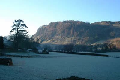
Walking the "Wainwrights" has one great advantage - it encourages you to explore the lesser heights of the Lake District with equal enthusiasm to the days spent in the high mountains. High Rigg is one such fell. Surrounded by much loftier peaks, including Helvellyn and Blencathra, it provides a taste of the higher fells without the effort required needed to gain the summit cairn of one of the giants. Ideal for a day shortened by bad weather, this Lake District walk starts within a few yards of a major road and soon gets you away from the hustle and bustle of daily life.
There is an adequate car park just off the A591 (Grid ref. NY318196). From here return to the main road and walk north over the river bridge, immediately turning right on a footpath that climbs the southern flanks of High Rigg. Take the left hand path where it splits and climb quickly to the top of Wren Crag. Most of the ascent is now over and it is a matter of following the path along the ridge. For most of the way it keeps to the western side and is easy to follow with the summit cairn visible ahead. For a low fell the views are surprisingly good. The panorama includes Thirlmere, Helvellyn, the eastern flanks of the Dodds, Clough Head, Blencathra, Skiddaw and the Central Fells.
A perfect place to rest, the summit cairn provides a grandstand view of Blencathra giving you the chance to review some of the routes to the summit. Suitably rested, continue steeply down to St John's Vale Church (worth a look inside) before taking the bridle-way which follows the wall along the eastern side of the fell. Eventually this leads you back to where the path forked at the start of the walk.
Maps 

| Ordnance Survey Explorer OL5 | Sheet Map | 1:25k | BUY |
| Anquet OS Explorer OL5 | Digital Map | 1:25k | BUY |
| Ordnance Survey Digital Map Subscription | |||
| Latest Ordnance Survey Discounts | |||
Other walks nearby
| Walk 2019 | Raven Crag, the Benn & Shoulthwaite Gill near Thirlmere | easy/mod | 4.0 miles |
| Walk 2032 | Great How, a short ascent above Thirlmere | easy | 2.0 miles |
| Walk 1247 | Helvellyn & Raise from Swirls | mod/hard | 7.0 miles |
| Walk 2025 | Helvellyn & Wythburn from Swirls | mod/hard | 8.5 miles |
| Walk 3132 | High Tove & Blea Tarn | moderate | 7.6 miles |
| Walk 2587 | Castlerigg Stone Circle & St John's in the Vale | easy/mod | 8.5 miles |
| Walk 1356 | Walla Crag | easy/mod | 4.5 miles |
| Walk 1108 | Ashness Bridge & Grange Fell | moderate | 9.0 miles |
| Walk 2525 | Standing Crag & Dock Tarn from Watendlath | moderate | 7.0 miles |
| Walk 2526 | Standing Crag, Ullscarf & Borrowdale | mod/hard | 10.0 miles |
Recommended Books & eBooks
Walking the Lake District Fells - Langdale
 Part of the Walking the Lake District Fells series, this guidebook covers a wide range of routes to 25 Lakeland summits that can be climbed from the Great Langdale valley, Ambleside and Grasmere, with highlights including Scafell Pike, Bowfell, the Langdale Pikes and Helm Crag (the Lion and the Lamb). Includes suggestions for longer ridge routes.
More information
Outdoor Adventures with Children - Lake District
 Guidebook to 40 outdoor adventures in the Lake District with children under 12, including walking, cycling, orienteering, paddling, boating, hostelling and more. Graded activities for varying age ranges or for families with children of different ages.
More information
