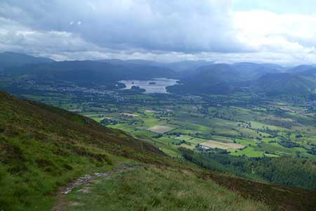
Ullock Pike & Carlside from near Keswick
Lake District Walk
Nat Park - Lake District - Lake District Northern Fells
Wainwrights - Carl Side, Dodd, Ullock Pike
County/Area - Cumbria
Author - John Paterson
Length - 5.5 miles / 8.9 km Ascent - 2500 feet / 758 metres
Time - 5 hours 20 minutes Grade - moderate
Walk Route Description
Click image to see photo description.
Skiddaw presents a problem to those who intend to climb all 214 "Wainwrights" - the fells listed by the famous guidebook writer. The massif and its outliers comprise 8 Wainwrights and no route of sensible length can be devised which climbs all of them without much doubling back. Most walkers will opt to climb the 8 peaks in at least two walks. This exhilarating and varied route is quite short but climbs the 4 Wainwrights on the western flank of the massif - with an optional ascent of the main summit of Skiddaw. There is also the bonus of a chance of spotting the Ospreys of Bassenthwaite Lake. The birds arrive from Africa in April and depart in mid September and with binoculars you may spot them fishing.
The start of this excellent Lake District walk is from a small carpark (Grid ref. NY234293)on the east side of the A591, 4 miles north of Keswick and 400 yards south of the Ravenstone Hotel. The carpark has a bus stop signed "Scarness Road End".
Take the woodland track north alongside the road for a few hundred yards until you are forced to turn east and climb steeply uphill. Pass though a gate in the intake wall onto the open fell. Head north east up the fellside to pick up a path which reaches the ridge at Ling How, a slight saddle (GR240302) It is worth detouring north for 200 yards to the "Watches" or "Watchstones" - a natural outcropping of rocks which makes a good foreground for pictures. From the Watches, head south up the ridge which gives easy walking over an airy traverse to Ullock Pike and Longside Edge. The views are exceptional - north to Scotland, west over Bassenthwaite Lake and east to the main summit of Skiddaw. The views to the south do not really open up until the tiny tarn at Carl Side Col (GR256283) is reached half a mile after Longside Edge. [ From the col there is the option of taking the very steep shaley path to Skiddaw summit which is just under a mile to the north east. This will add about an hour to the route.]
From Carl Side Col take the path heading south west to reach the summit of Carl Side after 200 yards. The path continues over the summit and descends steeply south. After half a mile "White Stones" is reached (GR254272 ). These are quartz boulders and mark the point where our route turns right (west) and leads down through heather to a col (GR250273) separating the outlying fell of Dodd from the main massif. A forest road and then a purpose built path lead to the summit after a climb of 400 feet. The Forestry Commission have felled the trees which used to clothe the summit of Dodd so it is once more a great viewpoint. From the summit, retrace your route to the col then turn left and head north west for 100 yards until the deep valley of Skill Beck is seen ahead. Bear right at the fork to follow the right bank of the beck and left at the next fork to stay close to the beck which is followed down through Dodd wood to meet the road at the carpark for the official Osprey viewpoint (May to September). A woodland footpath leads north for just over half a mile to the start of the walk.
Note - This walk takes place in the area where Ospreys are being regularly bred - after a break of 150 years. They breed on the opposite side of the lake but the viewpoint is on the lower slopes of Dodd. More information is available locally.
Maps 

| Ordnance Survey Explorer OL4 | Sheet Map | 1:25k | BUY |
| Anquet OS Explorer OL4 | Digital Map | 1:25k | BUY |
| Ordnance Survey Digital Map Subscription | |||
| Latest Ordnance Survey Discounts | |||
Other walks nearby
| Walk 1676 | Ullock Pike, Long Side and Carl Side | moderate | 5.5 miles |
| Walk 2041 | Barf (via the Bishop) and Lords Seat | mod/hard | 4.0 miles |
| Walk 2244 | Whitewater Dash and Great Calva | moderate | 7.0 miles |
| Walk 2581 | Lord's Seat & Barf from Whinlatter | moderate | 8.5 miles |
| Walk 1120 | Grisedale Pike & Crag Hill fro Braithwaite | mod/hard | 8.5 miles |
| Walk 2038 | Tower Ridge on Eel Crag returning via Sail & Barrow | hard | 6.3 miles |
| Walk 1073 | Skiddaw & Glenderaterra Beck | moderate | 9.0 miles |
| Walk 1244 | Lonscale Fell & Latrigg | moderate | 7.5 miles |
| Walk 3029 | Derwentwater & Walla Crag | easy/mod | 6.5 miles |
| Walk 3037 | High Seat & Bleaberry Fell from Keswick | moderate | 9.0 miles |
Recommended Books & eBooks
Lake District: High Level and Fell Walks
 This guidebook describes 30 graded fell walks on the ridges and high peaks of the English Lake District, the UK's most popular national park. Reaching some of England's finest and highest mountain scenery, this guide leads readers to classic horseshoes and traditional ascents as well as lesser-known routes to quieter summits.
More information
Walking the Lake District Fells - Buttermere
 Part of the Walking the Lake District Fells series, this guidebook covers a wide range of routes to 32 Lakeland summits that can be climbed from the Buttermere, Lorton and Newlands valleys, with highlights including Haystacks, High Stile, Grasmoor and the fells of the Coledale Round. Suggestions for longer ridge routes are also included.
More information
