Six Harbour Villages, Chichester
Chichester Harbour Walk
Region - Chichester Harbour
County/Area - West Sussex
Author - Chichester Harbour Conservancy
Length - 10.0 miles / 16.3 km Ascent - 150 feet / 45 metres
Time - 5 hours 10 minutes Grade - moderate
Maps 

| Ordnance Survey Explorer OL8 | Sheet Map | 1:25k | BUY |
| Anquet OS Explorer OL8 | Digital Map | 1:25k | BUY |
| Ordnance Survey Landranger 197 | Sheet Map | 1:50k | BUY |
| Anquet OS Landranger 197 | Digital Map | 1:50k | BUY |
Walk Route Description
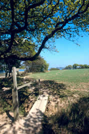
Click image to visit gallery of 3 images.
This is a circular walk of 10 miles from Fishbourne to Bosham, crossing the channel by ferry (fee payable) to ltchenor and then along to Birdham, Dell Quay and Apuldram, finishing back in Fishbourne. It is walkable any weekend from Easter to the end of September when the ferry is open. In summer months the ferry operates daily.
The starting point is the village of Fishbourne (grid ref. SU 843045). Please park with courtesy so as not to inconvenience local residents. Alternatively, you may wish to take the bus (No. 56 from Chichester) or drive to Bosham and pick up the route from these notes as appropriate.
We advise you to use these notes alongside the Ordnance Survey Explorer Map 120 (Chichester).
START by locating yourself in Fishbourne Parish Church car park at the opposite end to the church, near the car park entrance. Face towards the gate in the corner, with the car park entrance behind you. Cross over the stile into the first small field and straight over the next stile into the second, larger field. Other paths zigzag across this field but go straight across to the gateway in the furthest corner.
Pass through the gateway into a third field, which borders the head of the Fishbourne Channel.
Bear fight and cross over a low bridge. You will reach the stream.
Turn left along the stream and cross over the bridge. Bear right and follow the path out of the field through a kissing gate onto a narrow path alongside a wide ditch. Shortly, you will go through another kissing gate and will emerge onto a quiet road by Fishbourne Mill Pond.
Opposite the kissing gate you came through you will see a path leading ahead alongside the pond. Take this path, it bears left and then takes you through the spectacular reed beds.
Follow this path, crossing bridges with care (they may be slippery) over a few creeks. At high spring tides this is where the path may be flooded. The path will climb a few steps at the far side of the reeds and go up and bear left onto an embankment.
Follow this path, taking time to pause to view the harbour channel.
The path becomes very narrow and you will have to watch your steps for some way, but at the end it will descend a few steps to join the saltmarsh. The path continues across the saltmarsh and then passes between some oak trees.
Beyond these trees the path bears right and away from the shoreline. There is no public access further along the shoreline at this point. Follow the path inland. You will reach a T-junction of paths. Take the one to the right and 100 yards or so 1ater, go left. Keep going and you will reach a quiet road. Cross this road with care and straight onto the path on the other side. The path now travels in a westerly direction for about a mile, it detours an isolated house and joins a track (access to the house) for two hundred yards or so. Where the track turns left, go right over the small footbridge and left again across the last field.
You will reach a road and will need to descend a few steps. Take care crossing this road. You will need to go straight over and seem to Back into someone's property between the house and garage. This is correct! The footpath disappears over in the corner but the entrance s quite easy to see. Fe low this path with gardens and hedges on either side. You are now in Bosham. The path comes out on another small road and you will see the picturesque creek ahead. Take care cross rig this road and follow over the few yards of grass to meet the path on the embankment. You will see the heart of the village to your right.
At this point you may want to detour into the village to explore and take a break, there are two cafes and a pub, and the church is well worth a visit.
Turn left and follow the road round the creek. The footpath runs along the road bearing left and then right. You will come to the point opposite Bosham Quay - a good spot for photographs and taking in the view. The road bears left again and in 1 00 yards or so bears inland away from the shoreline. Stop at this point! Leave the road and take the shoreline route - this is the footpath but it is not very clear here as it is often flooded at high tide. Follow the shoreline and the footpath shows itself every now and then! Take time to enjoy the attractiveness of the shoreline here and the views of the Bosham channel. The route eventually bears left as it joins the main harbour channel.
You will come to the point opposite ltchenor with the channel called ltchenor Reach in between. You will now need to catch the ferry.
There are several points for boarding all depending on the level of the tide at the time. If the tide is low you will need to follow the gravel track winding down to the water. If the tide is higher, the track may be covered and you will need to wait by one of the small wooden 'jetties' you can see. Whichever it is, just stand and wait don't worry about signalling, the ferryman will see you and make his way across. If he is busy, allow 15 minutes for each return journey, take a rest! Sometimes the ferry man will take yachts people to their vessels just like a water taxi, so please be patient, he will be with you soon!
Once across the channel, this is a good place for a break.
The route now follows up the road for 200 yards or so until you reach the pub on your right, you will need to take the gravel track to your left, opposite the pub. Follow this track and you will emerge onto the shoreline once again. Follow the path to the right along the embankment for about half a mile. It will leave the shoreline and eventually meet a quiet road. Turn left and walk along this road with houses either side until it ends by the entrance to a house. The footpath bears oft to the right alongside a field with a small wood on the left. It then crosses the field on a diagonal route.
The footpath now skirts round the farmhouse and garden and joins the farm's concrete road. Turn right and down this road. At the end it passes two semi-detached farmhouses on the left and joins the tarmac road. Shortly after, take the road on the left, which is part of a smart housing estate. The road bears rounds to the right. After about 150 yards you will see the path slip oft to the left. Join this path, which takes you left then right and along a dip.
Follow this path, taking time to admire the views of the harbour channel. The path leads into and alongside a field. It meets a quiet road; go straight ahead, not to the left. The road bears round to the right to meet another road. Go left here and downhill, bearing right into Birdham Pool.
As you follow the road leaving the marina you will see the footpath go straight ahead (the road turns to the right). Take the path, which goes in between houses and crosses the approach road to some newish houses on your left. The path turns left here and behind a tall fence. It will come out at the side of the canal, which borders Chichester Marina.
Cross the canal over the footbridge. Turn right and past the Chichester Yacht Club into the Club's car parking area.
When you reach the road turn left and you will see the marina lock house straight ahead.
Approach the lock house because the footpath crosses the lock by footbridge at this point.
Your Ordnance Survey map is unlikely to show this route - it is a new permissive path funded by DEFRA (Department of the Environment, Food and Rural Affairs) as part of a Countryside Stewardship agreement with the farmer.
The route to lows the shoreline, entering a field. As the path and shoreline bears sharply to the right, stop to look at the view.
Follow the path along the field edge and into another field. Eventually the path turns sharp right and left to skirt a couple of houses. At the corner of the field the path leaves the field to emerge onto a road. Turn left and follow the road down into Dell Quay. You may want to stop at the pub rather than pass it! The road passes the pub and reaches the quay.
By the quay, the footpath goes off to the right, between the garden wall and the wooden building of the small boatyard. The route here is worn so walk with care. The path goes through a patch of recently established tree planting.
The route passes into a field. Cross straight across, towards the v-shaped stile. Pass through the stile and follow the path along the raised embankment along the shoreline. It does a zigzag. After this zigzag you will come to a point where there are two choices of route, one to the right across the field and the other to the left onto the shoreline field. You can take either route back to the start; as you are almost home you shouldn't get lost! The route the right is shorter and takes you back to the car park across 2 fields. The route to the left takes you back to the wetland fields where you started out, at which point you can retrace your steps back through these to the car park.
This walk is reproduced courtesy of Chichester Harbour Conservancy and is one of ten walks presented in a clear plastic wallet with an overall map of the Harbour shoring footpaths, roads, train and bus stops. The route details contained in the printed leaflets are supplemented by background information (omitted in this transcript) on the area in which you are walking.
Other walks nearby
| Walk 2828 | Dell Quay from Chichester Marina | easy | 3.8 miles |
| Walk 2368 | Bosham & Fishbourne | easy | 5.2 miles |
| Walk 1656 | Thorney Island circular from Prinsted | easy/mod | 9.0 miles |
| Walk 3548 | Stoughton, Kingley Vale & Bow Hill from Stoughton Down | easy/mod | 5.2 miles |
| Walk 2177 | West Wittering to Chichester (New Lipchis Way) | easy/mod | 9.2 miles |
| Walk 2043 | Thorney Island from Emsworth | easy/mod | 9.0 miles |
| Walk 1872 | Charlton, Singleton & Goodwood Circular | easy/mod | 6.5 miles |
| Walk 1835 | Treyford & Didling from Hooksway | easy/mod | 6.0 miles |
| Walk 3080 | Arundel Park and the River Arun | easy/mod | 7.2 miles |
| Walk 1423 | Midhurst Way - Arundel to Midhurst | mod/hard | 19.0 miles |
Recommended Books & eBooks
No suggestions for this area.Messaging & Social Media
Message Walking Britain and follow the latest news.

Mountain Weather
Stay safe on the mountains with detailed weather forecasts - for iOS devices or for Android devices.