Walk 2050 - printer friendly version
The Crown of Scotland Walk
Author - Simon Tweedie
Length - 9.0 miles / 14.6 km
Ascent - 1850 feet / 561 metres
Grade - moderate
Start - OS grid reference NT073107
Lat 55.381485 + Long -3.4646272
Postcode DG10 9LT (approx. location only)
An interesting walk that includes mystery, history, myth and fiction.
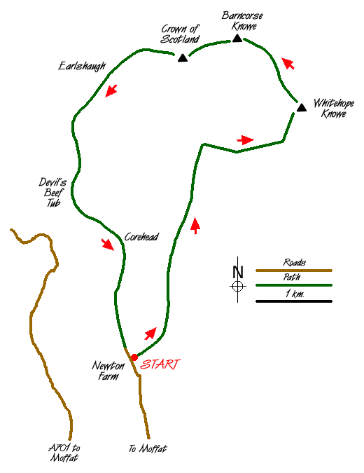
The Crown of Scotland, as its name proclaims, is of great historical importance. The start of this walk is some five miles north of Moffat which is to be found near Junction 15 of the M74/M6. Driving north out of the centre of the town take the A701 and turn right just past Moffat Academy. Continue along the old Edinburgh road until Newton Farm (Grid ref. NT073107) is reached. There is parking on the track opposite the farm that bears off to the right.
The walk starts by following this track through farm buildings for a hundred metres until you meet a bridge cum cattle crush constructed of motorway crash barriers. The route crosses the bridge but take a few minutes to deviate off just to the right. There is a mysterious red sandstone outcrop below Newton Farm Cottage. On the south face of this outcrop are two small caves. Arthurian legend has it that Merlin spent his final years living in a cave on Arthur's Seat, which is just to the east, and roaming the hills often in the guise of a deer or hart. Perhaps it was these small caves that played host to the great Magician.
Cross the bridge and continue along the track passing through a number of farm gates and fields. Though the map marks a direct route through the field system some deviation is necessary to find the gates and avoid the fences as the route becomes indistinct. As you climb above the valley floor to the left Corehead is visible. Corehead has strong connections with Robert the Bruce of which there is more in a minute. Heading past Broad Tae (Big Toe) up the right of Tweedhope Burn the country opens up between Chalk Rig Edge and Spout Craig. The Crown of Scotland is clearly visible across the Powskein Burn.
Follow the county boundary easterly along the Tweed/Annan watershed up to Whitehope Heights and continue to Whitehope Knowe. Strike off north to Garlet Hill, do not loose too much precious height as Lamb Craig and Barncorse Knowe are taken in before the short pull up to The Crown of Scotland. It is at this spot in 1306 having murdered his rival the Red Comyn in Dumfries that Robert the Bruce forged an alliance with James Douglas that resulted in Bruce becoming Scotland's most celebrated king.
The source of the River Tweed is visible to the west and to the north Broad Law can be seen above Tweedsmuir, which brings us neatly to the fictional character of Richard Hannay the creation of John Buchan who took the title Viscount Tweedsmuir on becoming the governor of Canada. He is better known now as the author of the famous thriller Thirty-nine Steps the father of all chase novels. It is over these hills and glens before you that his hero Richard Hannay is pursued by evil villains until finding refuge in "a humble Moffat public-house" so let us move on swiftly.
From the Crown drop down to the ruined buildings at Earlshaugh and follow the track southerly to Strait Step. Enter the great Devil's Beef Tub a vast coomb that forms the head of Annandale. By tradition, it is here that cattle purloined or reived from over the border in England were hidden before being dispersed. Taking care on the scree, pick up the path at Corehead and from there it is but a short walk back to Newton Farm.
Messaging & Social Media
Message Walking Britain and follow the latest news.

Mountain Weather
Stay safe on the mountains with detailed weather forecasts - for iOS devices or for Android devices.