Wendover Woods
Chilterns Walk
Region - Chilterns
County/Area - Buckinghamshire - North Buckinghamshire
Author - Chilterns AONB
Length - 7.0 miles / 11.4 km Ascent - 600 feet / 182 metres
Time - 4 hours 10 minutes Grade - easy/mod
Walk Route Description
Click image to see photo description.
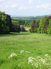
This Wendoner Woods walk takes you to the top of the Chiltern Hills, through ancient beech woods, carpets of bluebells and wild flowers. There are amazing views of the Vale of Aylesbury and you might also see rare birds such as Red Kites and Firecrests and the tiny Muntjac Deer.
The start is Wendover Rail Station, which is just a 45 minute train ride from London Marylebone. Within a few minutes walk from Wendover station you can enjoy the fresh air and fantastic views of the Chilterns countryside including Wendover Woods.
Access Information : There are no stiles on this route, but 1 kissing gate (not wheelchair accessible, at the Hale into Wendover Woods). From Wendover along the Ridgeway to the Hale the paths are wide and firm (with some loose stones) but there is a considerable uphill slope.
The Walk : Leave Wendover railway station (grid ref SP865077) by the road and turn left past the Shoulder of Mutton pub. Continue along Wendover High Street past the shops. Cross the road at the pedestrian crossing and continue down the High Street.
Just after the last shop turn right onto a footpath (signposted "Ridgeway"), which passes through a park alongside a stream - continue to follow "Ridgeway" signs. Go straight on, following The Ridgeway National Trail signs (which is waymarked with an acorn symbol) past the lake and church and along the road. At the crossroads go straight across, up Hogtrough Lane.
Continue to follow The Ridgeway, which takes the left path after Boswell's Farm into woodland. Follow this forest trail for over 1 mile gently uphill. You will eventually cross Hale Road and enter Wendover Woods. Leave The Ridgeway by turning left, downhill and after 30 metres follow a footpath to the right and then join a marked horse track. Turn right and follow this track which takes you through Wendover Woods to the main car park.
Follow the tarmac road to the left, then turn left and follow the wide track for ½ mile, which passes picnic areas with barbeques to a final parking area. Keep straight on following the Boddington Bank Walk. After 300 metres there is a piece of fitness equipment (part of the fitness trail): do not turn left here - go straight on and follow the track downhill. You will eventually meet another track, turn right and join this track, continuing downhill. Then carry straight on until you reach the road at the bottom.
Turn right and follow the road back to Wendover (Please take care if walking on the road). At the junction turn right and after 50 metres take the path between houses on your left. This brings you back to the park at the start of the walk. Follow the stream and then on to the Heron Path to come out on the High Street by the Clock Tower. Turn left and walk back up the High Street to the rail station.
This is one of a series of walks through the Chilterns Area of Outstanding Natural Beauty. It mainly follows rights of way most of which are waymarked with either yellow arrows (footpaths), blue arrows (bridleways) or red arrows (byways).
Maps 

| Ordnance Survey Explorer 181 | Sheet Map | 1:25k | BUY |
| Anquet OS Explorer 181 | Digital Map | 1:25k | BUY |
| Ordnance Survey Digital Map Subscription | |||
| Latest Ordnance Survey Discounts | |||
Other walks nearby
| Walk 1138 | The Ridgeway at Chequers | easy/mod | 7.3 miles |
| Walk 2478 | Great Kimble Circular | moderate | 11.2 miles |
| Walk 3360 | Cholesbury Camp and Hawridge | easy | 4.4 miles |
| Walk 3098 | Tring & Wendover Woods | easy/mod | 7.5 miles |
| Walk 3669 | Grand Union Canal - Aylesbury to Wendover | moderate | 11.7 miles |
| Walk 3520 | Princes Risborough circular | easy/mod | 9.5 miles |
| Walk 2071 | Ivinghoe Beacon and Bridgewater Monument from Tring | easy/mod | 8.0 miles |
| Walk 2496 | Cow Roast and Aldbury from Tring Station | easy | 5.5 miles |
| Walk 1617 | Saunderton circular via Bledlow Ridge | moderate | 11.3 miles |
| Walk 2763 | Ivinghoe Beacon Circular | moderate | 8.2 miles |
