Walk 2068 - printer friendly version
Maxwell's Otter and Monreith Beach Walk
Author - Eric Lucas
Length - 6.0 miles / 9.8 km
Ascent - 350 feet / 106 metres
Grade - easy
Start - OS grid reference NX365394
Lat 54.722936 + Long -4.5402042
Postcode DG8 8NJ (approx. location only)
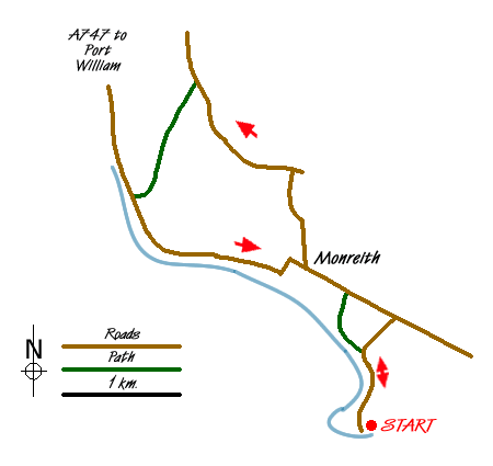
From Port William, follow the A747 south east. Pass through Monreith and at the top of a rise, opposite Knock Farm Caravan Site, take an unclassified road on the right and follow this single track road down through St Medans Golf Course to a car park at a beach (grid ref. NX365394) where there are toilets.
After parking retrace your steps up the road and opposite the Golf Club Car Park there is a grassy track which goes left and leads to the disused Kirkmaiden Church with its picturesque graveyard overlooking Monreith Bay. Come back up the grassy track and turn left along the road passing the Golf Club on your right until you come to the Otter Memorial to Gavin Maxwell (who wrote Ring of Bright Water) and whose descendents still live in the area at Monreith House.
From the Otter Memorial take a track on the right which leads you in a northerly direction towards the village of Monreith. Pass through two wooden gates and then bear left along the fence until you come to a gate which leads down to the pebbly beach. Here you turn right along the beach until you see a track going up past a house on the left. Follow this track, Mill Lane, to the main road.
Turn left along the main road and, just before a sharp left hand bend, take an estate road on your right. Follow this to a village hall and pass this on your right following a grassy track with a stream on your left. Eventually you come to a road by a bridge (grid ref. NX358418) and turn left along the road, following this to an unclassified road. Here you turn right, passing a cottage on your right and coming to a footpath sign "North Barsalloch and Beach 1M".
Follow this track past the farmhouse, through a glen and past a cottage on your left to join the A747 again. Turn left and, depending upon the tidal state, you can either follow the beach back to the track you first came down (which does involve fording a stream which crosses the beach) or follow the road back up towards Monreith, either retracing your steps down Mill Lane, or going right through the village and taking the footpath on your right at Clarksburn which is signed for the Otter Memorial and takes you back to where you started.
There are extensive seascape vistas right over to the Mull of Galloway Lighthouse and the Scares Rocks, which are a protected sea bird colony.
Messaging & Social Media
Message Walking Britain and follow the latest news.

Mountain Weather
Stay safe on the mountains with detailed weather forecasts - for iOS devices or for Android devices.