Walk 2077 - printer friendly version
Glaisdale Moor circular Walk
Author - Andy Chaplin
Length - 11.9 miles / 19.3 km
Ascent - 1220 feet / 370 metres
Grade - moderate
Start - OS grid reference NZ745002
Lat 54.3918390 + Long -0.8541691
Postcode YO21 2QA (approx. location only)
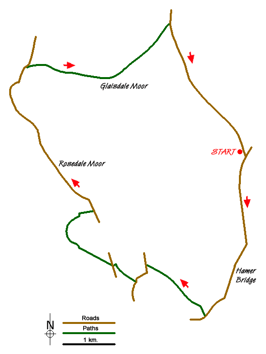
There are two disadvantages to this circular walk in the North York Moors National Park - firstly a fair amount of it is on roads and secondly the route goes on both sides of both North York Moors OS Explorer Maps. On the plus side the roads are quiet and unfenced, the views of North dale, Rosedale, the Fryup Dales and Glaisdale are beautiful and if it is not too windy then you may return with both maps intact.
There is enough off road parking at grid ref NZ745002 near Lamb Fold Hill for about 10 cars. From here walk south down Smiths Lane and Hamer Bank to Hamer bridge and just after the Hancow Road goes off on the left, take the track off on the right. Follow it until you are just below Brown Hill then do 20 meters across country to the permissive track below you. Follow this through a gate in the wall and after 250 meters angle off left on the path towards Northdale Farm.
Take the track down to Hangingstone Lane, turn left down to the Northdale Beck then take the footpath of on the right after crossing the bridge. The path climbs up the west side of Northdale until it curves around to come up to Knott Road. Go right on the road then immediately off left on another well-signed path on what was a former tramway connecting to the former Rosedale railway loop.
After the path bends left after crossing a stream, take the signed path off right through the trees. The path was obscured here in 2015 due to fallen trees, but it will come out above the wood, climb uphill then lead across 2 stiles in the corner of a field and onto a moors track. Follow this all the way back to Knott Road.
Turn left on the road and follow it to the point where the bridleways cross it. This is the Coast to Coast path coming from the Lion Inn on the far side of Rosedale and you take it off right towards Fryup Dale head. It is paved in sections and is the George Gap Causeway until it meets the Cut Road path. The views of Fryup dales and Glaisdale are great from both the Cut Road path and, when you reach it and turn right on the road, on the final 2km on the road back to the parking spot.
Messaging & Social Media
Message Walking Britain and follow the latest news.

Mountain Weather
Stay safe on the mountains with detailed weather forecasts - for iOS devices or for Android devices.