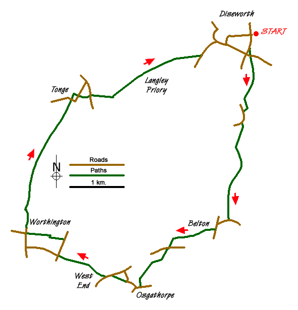
Walk 2080 - printer friendly version
Belton, Osgathorpe, & Worthington Walk
Author - David McMahon
Length - 10.3 miles / 16.7 km
Ascent - 650 feet / 197 metres
Grade - easy/mod
Start - OS grid reference SK453245
Lat 52.816145 + Long -1.3293017
Postcode DE74 2AE (approx. location only)
This Leicestershire walk visits four historic villages in the North West corner of Leicestershire, south of East Midlands Airport, but fortunately not under its flight path. A longer version of this walk is available at Walk 2234. A number of bus services can be used. Kinchbus's Skylink from Leicester, EMA and Derby serves Diseworth. Roberts Coaches Service route 155 from Coalville to Castle Donington passes through Worthington; and Cresswell Coaches route 129 from Loughborough (Swan St) to Ashby(see timetable) calls at Osgathorpe.
The walk commences from the staggered crossroads at the heart of the village of Diseworth. Walk south down Ladygate and take a very short footpath on the left just short of the road junction. You then turn left, cross the road and take the lane on the right. Go through the farm gate and walk parallel to the hedgerow to the top of the field. Pass through another farm gate and once more follow the hedgerow to reach a kissing gate into the next field. Turn left and head for the centre of the hedgerow at the top of the field. Pass through into the next field and head diagonally right to a gap in the boundary of the third field. Once through, aim diagonally right to a point about a quarter of the way down on the right-hand side of the field towards what is a well-concealed stile. Into the next field and head down the slope for the bottom right-hand corner of the field. Once you have reached it you can go through the farm gate and turn left along the side road or carry on along the hedgerow to find yet another well-hidden stile. Go over the stile, turn left and climb a flight of stairs, which will bring you onto the aforementioned side road (grid ref. SK451230).
Turn left and cross the A42 road. After that, the road swings to the right. Take the footpath on the left. Carry on along with the hedgerow on the left until you reach a yellow post and then turn sharp right and head for the equivalent on the opposite side of the field. Go into the next field and head diagonally to the far left-hand corner. After the stile, cross a footbridge (most definitely not designed by Isambard Kingdom Brunel) and walk diagonally right to the top of the slope. Over the stile and head straight ahead for the line of trees in the distance. Once you have reached them carry on along the grassy lane (Bromley Lane), which will bring you into Belton (grid ref. SK449208).
Turn right onto the road, walk past the parish church and the 'Queens Head' pub. Alternatively, you can swing left after the church into Vicarage Lane and at its end turn right onto School Lane. Either way you need to find an alleyway almost opposite the junction with School Lane. Once found, walk along it until you reach a stile. Then turn diagonally left. Head for the yellow post and after the second of two stiles turn sharp right and follow the hedgeline until you come out onto a minor road (grid ref. SK438205). Go left and walk along it to the road junction. Go straight across the road and follow the headland until you reach a hedgerow coming in from the left. Go to the right of it and continue through the second wooden gate. Carry on with the fence on your left-hand side, through another wooden gate, followed by some steps and the next wooden gate. Go down some steps and follow the hedgeline to cross a footbridge. Turn right into the field immediately after the bridge and then go diagonally left to the right-hand corner of the field. Continue over the stile, into a driveway and walk down onto the Main Street of Osgathorpe (grid ref. SK431195).
Turn right and follow the road through several bends. On the second right-hand one take the lane off to the left. Go over the stile into the field and follow the hedgeline to the right. When it curves away further to the right keep a straight line and head for the far left-hand corner of the field. Reaching a road, walk left. Note At this point you will see, to the left, a service road which could be used for car parking by anyone wishing to have a different starting point.
To carry on walking you will see a footpath off to the right. Cross the road and take this path as it eventually curves off to the right into a wood. Continue up a slope, then turn left and continue along the path as it goes to the right of the farm and onto the road (grid ref. SK415201). Here you have a choice. You can continue straight ahead down Bull Hill and turn right further along onto the side road or turn right and pick up the footpath on the left -hand side. Once you have made your choice and reached the second footpath (grid ref. SK413205), climb the stile and head for the nearby village of Worthington. Pass through several gates and, when you see a driveway in front of you, look out for the official footpath which passes through a wrought iron gate on the right-hand side and into the village proper. Turn left for the 'the Malt Shovel' the local hostelry.
Before continuing the walk, go straight ahead up the slope to view 'The Roundhouse' an Eighteen Century lock-up. Return down the slope and turn right along Manor Drive. Where it curves off the left, take the track straight ahead. When the track turns off to the right go straight ahead and on to the cycle track. Turn left and when you reach a junction with another cycle track turn right and you'll be on the 'Cloud Trail’. Carry on until you reach a dead-end and you turn left up a slope and right again at the top to take you over the A42. At the other side take the cycle track which runs parallel to the motorway. Follow this trail and you pass several bridges, one of which takes you into Tonge itself, but you require the bridge immediately after, which has stairs on the right-hand side. Climb the stairs and go right at the top. Cross the field into the road and carry on into the driveway. Continue into the field, straight across into the second field and then diagonally left and diagonally right once you are into the next field. Go through the gap in the hedgerow and up onto theA453 road (grid ref. SK421233).
Go straight across the road and up the centre of the field. Walk to the right of the solitary tree and telegraph pole. When you reach the top of the slope you can see a yellow post off to the left; head for it and climb the adjacent stile. Aim for the yellow post on the opposite side of the field and carry on through the green lane into another field. Walk diagonally right; climb the stile and then aim diagonally left for the yellow post midway along the hedgerow. Cross the driveway to Langley Priory (grid ref. SK430236) and into the next field. Carry on diagonally right to the next field boundary and likewise afterwards. Aim for the far right-hand corner of the field and when you are nearer to it you will see a stile over the fence on your right-hand side. Change direction for the stile and then go over the bridge, through the gate and a broken stile. Then aim slightly diagonally left up the slope and carry on east along the farm track until you reach the road (grid ref. SK443241).
Turn left along the road and you will see a footpath sign on the left. This short path, which runs parallel to the road has a very awkward stile at the far end and needs great care to negotiate. Alternatively walk along the road and go left at the junction. Walk along the road and you will see a lane on the right-hand side just on a corner (grid ref. SK446246). Once there, take the footpath and head slightly diagonally left across the field to the very last stile on the walk. Turn left along the road and you will pass 'The Plough' pub on the way back to your starting point.
Messaging & Social Media
Message Walking Britain and follow the latest news.

Mountain Weather
Stay safe on the mountains with detailed weather forecasts - for iOS devices or for Android devices.