Walk 2091 - printer friendly version
Kettleness and Mickleby from Lythe Walk
Author - Andy Chaplin
Length - 9.7 miles / 15.8 km
Ascent - 1040 feet / 315 metres
Grade - moderate
Start - OS grid reference NZ846130
Lat 54.5052670 + Long -0.6950143
Postcode YO21 3RS (approx. location only)
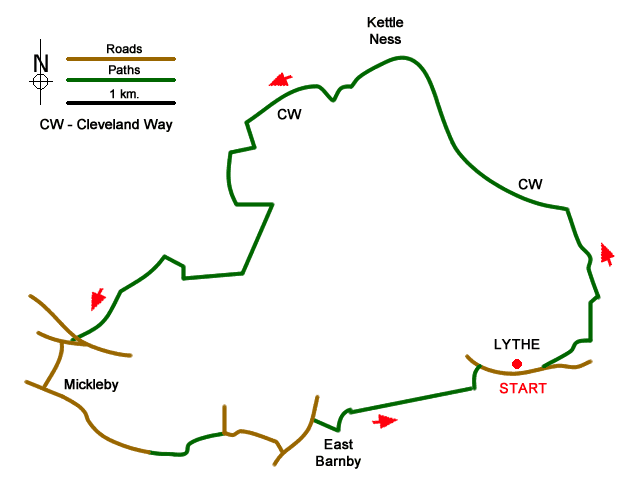
This North York Moors walk starts in Lythe, follows the Cleveland Way towards Runswick Bay then comes inland to Mickleby and takes a route back to Lythe through West and East Barnby where you overlook the valley of the Mickleby and Barnby becks.
Park in the Lythe village car park (grid ref. NZ846130) and walk east along the main road until the first footpath off on the left. This cuts a corner off to reach the track that leads behind the church and on to Deepgrove farm. Take the path behind the farm, not the one signed to Sandsend, and follow it across the footbridge over Overdale stream and continue to the Cleveland Way at Tellgreen Hill.
Follow the Cleveland Way through Kettleness then, when the old railway track and the coastal path come close together go off left through the field to the railway track. The path signage was poor for the next part of the route in late 2016 and the permissive path on the railway westwards said it was closed (although a local farmer said it was not).
When you are on the old railway go east a little way to just before a railway-themed bench and walk up through the first field until a path crosses before the next gate. Go west then south past Claymore and then continue along the track towards Brockrigg Farm. Keeping to paths on the edges of the fields head south for Barnby Tofts. The gate near the stream at NZ823143 was tied shut and had no path marker on it but it is still a footpath and does come out past the farm at NZ821139.
Turn right and head towards Westfields Farm. There are great views back towards the coast and along to Boulby. The path markers through the farm are poor but stay north then west of the buildings and you will find yourself on the path to High Dale and Mickleby Hole. Cross the main road and take the minor road into Mickleby. Turn left at the junction in the village and follow the no-through road towards Mickleby Low Grange. Just before the grange there is an access route across the fields to Ferndale Farm in West Barnby. It was poorly signed in 2016 and seemed to be south of the Barnby beck for longer than shown on the map - crossing over on a farm track bridge.
From Ferndale Farm take the imaginatively names West Barnby road and East Barnby road to East Barnby then go off right and take the path on the edge of Cow Pasture Plantation all the way to the Sports club in Lythe. On the way, there are now good views into the Sandsend Beck valley. When you reach the sports field the path seems to follow the inside of the south then the east boundary of the ground. Come out on the main road and go right which takes you back towards the parking.
Messaging & Social Media
Message Walking Britain and follow the latest news.

Mountain Weather
Stay safe on the mountains with detailed weather forecasts - for iOS devices or for Android devices.