Walk 2152 - printer friendly version
Hartshope Linn (waterfall) from Langleeford Walk
Author - Lou Johnson
Length - 4.4 miles / 7.2 km
Ascent - 500 feet / 152 metres
Grade - easy
Start - OS grid reference NT953225
Lat 55.4962650 + Long -2.0759479
Postcode NE71 6RG (approx. location only)
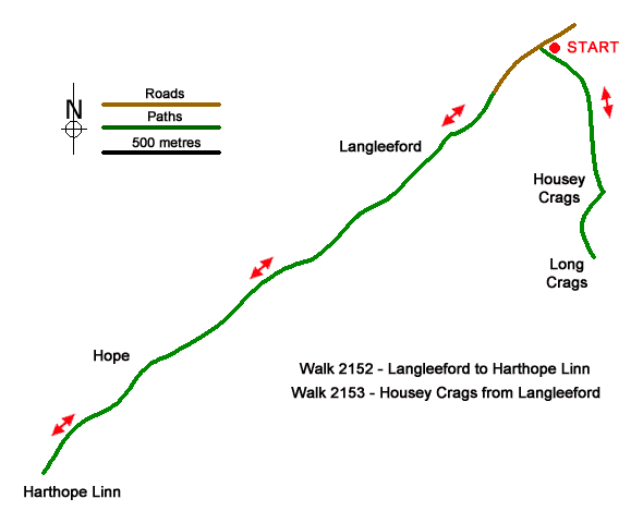
A linear walk from Langleeford exploring the Harthope Burn valley. Lying on the south flank of the Cheviot, the highest summit in the Northumberland National Park, the valley is wild with sheep the only inhabitants. Quiet and remote, the valley offers a peaceful walk in glorious surroundings. The route follows the Harthope Burn upstream to reach the waterfall of Harthope Linn. After rain you can expect an impressive sight. This walk can easily be combined with Walk 2153 - Housey Crags.
The walk starts from a roadside parking are on the south side of the road into the valley from Wooler (grid ref. NT953225). about 600 metres before reaching Langleeford. After parking, head west up the road past to Langleeford Farm and take the track through a gate. The clear track up the valley passes farm buildings at Langleeford Hope (grid ref. NT933208). Shortly after the track ends and the route continues on the north side of Harthope Burn soon passing sheep pens before reaching Harthope Linn (grid ref. NT928203).
To return to the start retrace your steps down the valley back to the parking area.
Messaging & Social Media
Message Walking Britain and follow the latest news.

Mountain Weather
Stay safe on the mountains with detailed weather forecasts - for iOS devices or for Android devices.