Hartshope Linn (waterfall) from Langleeford
Northumberland Walk
Nat Park - Northumberland
County/Area - Northumberland County
Author - Lou Johnson
Length - 4.4 miles / 7.2 km Ascent - 500 feet / 152 metres
Time - 2 hours 40 minutes Grade - easy
Walk Route Description
Click image to see photo description.
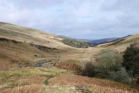
A linear walk from Langleeford exploring the Harthope Burn valley. Lying on the south flank of the Cheviot, the highest summit in the Northumberland National Park, the valley is wild with sheep the only inhabitants. Quiet and remote, the valley offers a peaceful walk in glorious surroundings. The route follows the Harthope Burn upstream to reach the waterfall of Harthope Linn. After rain you can expect an impressive sight. This walk can easily be combined with Walk 2153 - Housey Crags.
The walk starts from a roadside parking are on the south side of the road into the valley from Wooler (grid ref. NT953225). about 600 metres before reaching Langleeford. After parking, head west up the road past to Langleeford Farm and take the track through a gate. The clear track up the valley passes farm buildings at Langleeford Hope (grid ref. NT933208). Shortly after the track ends and the route continues on the north side of Harthope Burn soon passing sheep pens before reaching Harthope Linn (grid ref. NT928203).
To return to the start retrace your steps down the valley back to the parking area.
Maps 

| Ordnance Survey Explorer OL16 | Sheet Map | 1:25k | BUY |
| Anquet OS Explorer OL16 | Digital Map | 1:25k | BUY |
| Ordnance Survey Digital Map Subscription | |||
| Latest Ordnance Survey Discounts | |||
Other walks nearby
| Walk 1766 | Cushat Law and Bloodybush Edge from Hartside | mod/hard | 12.5 miles |
| Walk 2299 | The Cheviot | moderate | 9.0 miles |
| Walk 1314 | Great Hetha and Elsdon Burn from Hethpool | easy/mod | 4.0 miles |
| Walk 3644 | Blackhaggs Rigg & Great Hetha from Hethpool | moderate | 9.6 miles |
| Walk 3646 | Hethpool, Sutherland Bridge & Great Hetha | moderate | 6.0 miles |
| Walk 3739 | Elsdonburn & Trowupburn from Hethpool | moderate | 8.2 miles |
| Walk 1805 | An introduction to the Breamish Valley | easy | 2.0 miles |
| Walk 2677 | Circuit of Doddington Moor | easy | 3.8 miles |
| Walk 1201 | Black Hag from Kirk Yetholm | moderate | 8.5 miles |
| Walk 1200 | Windy Gyle | moderate | 7.5 miles |
Recommended Books & eBooks
Walking in Northumberland
 This guidebook contains detailed route descriptions for 36 day walks in Northumberland including the Cheviot Hills. The terrain varies from wild walks and craggy ascents to gentle riverside strolls. Each route ranges from 4 to 16 miles in length and there is the opportunity to link several walks together to create longer treks.
More information
Hadrian's Wall Path
 Hadrians Wall Path guidebook to walk the 84 mile National Trail. Described in both directions, the main description is west to east between Bowness-on-Solway and Wallsend, Newcastle, with extensions to Maryport and South Shields. With extensive historical information related to this World Heritage site and separate 1:25,000 OS map booklet included.
More information
