Clougha Pike from the Jubilee Tower
Forest of Bowland Walk
Region - Forest of Bowland
County/Area - Lancashire
Author - Lou Johnson
Length - 4.7 miles / 7.6 km Ascent - 800 feet / 242 metres
Time - 3 hours 10 minutes Grade - easy/mod
Walk Route Description
Click image to see photo description.
This short but rewarding walk to the summit of Clougha Pike offers excellent views over Lancaster and beyond. The route follows clear paths across moorland which can be wet underfoot after heavy rain. The walk covers the high ground on the western edge of the Forest of Bowland and serves as a useful introduction to walking in this Area of Outstanding Natural Beauty.
The start is the car park adjacent to the Jubilee Tower (grid ref. SD542573) which is located on a minor road between Quernmore and Lower Less southeast of Lancaster and the M6. It is possible to climb the tower which offers a great view especially to the southwest. The walk starts from the rear of the car park and follows the fence steadily up the fell with improving views as you gain height. Reaching the third boundary post (grid ref. SD557589). A short diversion to the right takes you to the top of Grit Fell which is marked with a cairn.
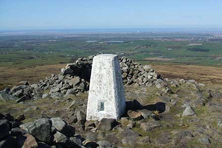
After enjoying the view return to the boundary stone and continue ahead (northwest) and descend across rough moorland. The path reaches a stile which is crossed to reach the summit Of Clougha Pike (413 m.). The view is extensive including the City of Lancaster, Morecambe Bay and the Lake District Fells. It is worth spending some time exploring the immediate are including rocky Clougha Scar to the north and a number of impressive cairns scattered across the landscape.
The return route follows the outward path down to the Jubilee Tower. During descent you can appreciate the view southwest which includes the rolling hills of the Forest of Bowland.
Maps 

| Ordnance Survey Explorer OL41 | Sheet Map | 1:25k | BUY |
| Anquet OS Explorer OL41 | Digital Map | 1:25k | BUY |
| Ordnance Survey Digital Map Subscription | |||
| Latest Ordnance Survey Discounts | |||
Other walks nearby
| Walk 2257 | Clougha Pike from Quernmore | easy/mod | 4.8 miles |
| Walk 2278 | Ward's Stone from Stoops Bridge | mod/hard | 13.0 miles |
| Walk 3459 | Abbeystead Reservoir Circular | easy | 1.6 miles |
| Walk 3457 | Wyre Valley Circular | easy/mod | 6.4 miles |
| Walk 2137 | Clougha & Goldsworthy's Installation Circular | moderate | 5.2 miles |
| Walk 3038 | Wolfhole Crag from Tower Lodge | moderate | 9.0 miles |
| Walk 1994 | Cockerham, Glasson & Conder Green | easy/mod | 6.6 miles |
| Walk 1641 | Bankhouses via the Lancashire Coastal Way | easy/mod | 7.0 miles |
| Walk 1218 | Fiensdale Head & Bleasdale Water | moderate | 10.0 miles |
| Walk 1670 | Hazelhurst Fell, Fair Snape Fell and Parlick | moderate | 11.0 miles |
Recommended Books & eBooks
Walking in the Forest of Bowland and Pendle
 A guidebook to 40 diverse circular day walks suitable for walkers with navigational skills. The Forest of Bowland and Pendle are two of north west England's upland AONBs, perfect for walkers who enjoy exploring rough hilly, sometimes pathless terrain. The routes include Ward's Stone, Pendle Hill, Longridge Fell and Fair Snape Fell.
More information
Walking on the West Pennine Moors
 This guidebook describes 30 walks on the West Pennine Moors, around Blackburn, Darwen, Chorley and Bolton, home to some of the most inspiring and exhilarating walking country. The walks range from short, easy rambles to more challenging hikes covering a variety of terrain, all of it easily accessible for day walking.
More information
