 Walking Britain
Abbeystead Reservoir Circular from Stoops Bridge
Forest of Bowland Walk
Region - Forest of Bowland
County/Area - Lancashire
Author - Lou Johnson
Length - 1.6 miles / 2.6 km Ascent - 150 feet / 45 metres
Time - 0 hours 50 minutes Grade - easy
Walk Route Description
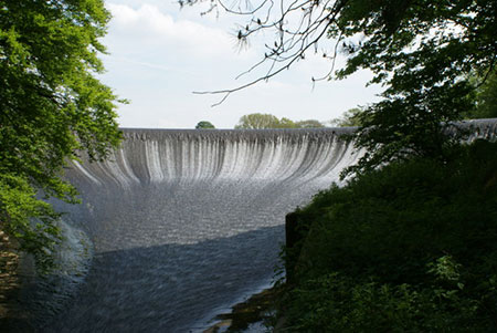
Click image to see photo description.
An easy Lancashire walk from Stoops Bridge in the beautiful Wyre Valley. The route offers excellent views of the reservoir and dam before passing through the immaculate estate village of Abbeystead. After rain, the path through Hinberry Wood can be muddy.
The start is the small car park by Stoops Bridge by the River Wyre (grid ref. SD563544). After parking walk south along the lane with the river on your right. After 200 metres you cross the Marshaw Wyre River, a tributary of the Wyre. Turn right off the lane following a permissive path through Hinberry Wood. The path soon runs alongside the reservoir and continues to pass the dam. Continue ahead to reach a footbridge. Turn right and cross the river.
Once across the river, bear right and follow the Wyre Way initially alongside the reservoir before turning right to reach Abbeystead Lane at a ladder stile. Turn right along the lane and walk downhill and through the village. Pass the village school on your left and you are soon back at the start.
Maps 
| Ordnance Survey Explorer OL41 | Sheet Map | 1:25k | BUY |
| Get Ordnance Survey Digital Map Subscription | |||
| Latest Ordnance Survey Discounts | |||
Other walks nearby
| Walk 2278 | Ward's Stone from Stoops Bridge | mod/hard | 13.0 miles |
| Walk 3457 | Wyre Valley Circular from Abbeystead | easy/mod | 6.4 miles |
| Walk 1742 | Grit Fell from the Jubilee Tower near Quernmore | moderate | 7.7 miles |
| Walk 2164 | Clougha Pike from the Jubilee Tower | easy/mod | 4.7 miles |
| Walk 3038 | Wolfhole Crag from Tower Lodge | moderate | 9.0 miles |
Start Point Details
Ordnance Survey Grid Ref SD563544
Latitude 53.9837940 Longitude -2.6678864
Postcode LA2 9BH
what3words start repayment.taken.crossword
Walk description may contain detailed information on the start point for this walk.
Further Information
Forest of Bowland Walking
The Forest of Bowland walks cater for walkers of all abilities from easy low-level walks to walks across the hills and moors. All walks are free to download and print and all routes have GPS files. The walks cover the highlights of this area including Pendle Hill, Whin Fell and Dunsop Fell as well the valleys and moors of this beautiful part of England.
Walking GuideAccommodation
Find Accommodation nearby by using the regional accommodation lists
Go to regional accommodation lists
Self Catering & Cottage Holidays
Properties throughout the UK & Europe
Messaging & Social Media
Message Walking Britain and follow the latest news.


Mountain Weather
Stay safe on the mountains with detailed weather forecasts - for iOS devices.