Walk 2176 - printer friendly version
Wrekin Circular Walk
Author - Lou Johnson
Length - 4.5 miles / 7.3 km
Ascent - 1300 feet / 394 metres
Grade - easy/mod
Start - OS grid reference SJ638092
Lat 52.679281 + Long -2.5368732
Postcode TF6 5AL (approx. location only)
The Wrekin is one of a string of volcanic hills stretching from Telford south to Church Stretton near the Long Mynd. Dominating the modern town of Telford, the hill can easily be seen from the north across the flat lands of Staffordshire, Shropshire and Cheshire. Rising quite abruptly from the surrounding countryside it is no surprise that it makes an excellent viewpoint and each year it sees many visitors at its summit. This route follows a quieter approach and provides an excellent half day excursion.
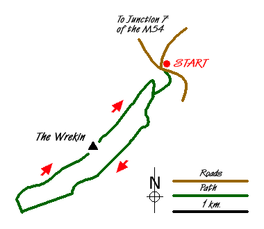
The start is the car park (Grid ref. SJ638092) on the minor road leading from Cluddley (Junction 7 of the M54) to the village of Little Wenlock. After parking cross the road and take the footpath that leads southeast in front of the derelict toilet block. Climbing gently the path turns south-west to reach a junction (Grid ref. SJ637088). Bear left here and take the clear path that undulates across the south-eastern flank of the Wrekin passing through delightful mixed woodland. Reaching a major junction (Grid ref. SJ629077), keep straight ahead, ignoring the tempting path rising to the right.
A short way further you reach another junction (Grid ref. SJ625074). Bear right here to continue through woodland. You are now reaching a section of the wood that has many paths and care is needed. Reaching an indistinct junction, stay with the main path bearing right past a footpath sign. This leads in about 400 metres to a broader track where you turn right. After a short distance look out for a narrow path (Grid ref. SJ617073) going right and climbing between trees. Despite being the Shropshire Way, this path is hard to spot.
Assuming the path has been located, climb steeply on the narrow path to the summit of Little Hill. Sadly trees restrict the view and it is better to descend to the col and a crossing path (Grid ref. SJ620076). Go straight over here and continue the climb. It is again very steep at first but as the trees thin the gradient eases and quite soon you are able to enjoy the views over the surrounding Shropshire countryside. Ahead you will see the trig point and a brass topograph. Joining the main track, continue northeast along the main ridge past the radio mast. Some way beyond the track doubles back on itself to reach a gate. Go through the gate passing the small café on your left and descend to a path junction. Turn left and within a few minutes you will be back at the start.
Messaging & Social Media
Message Walking Britain and follow the latest news.

Mountain Weather
Stay safe on the mountains with detailed weather forecasts - for iOS devices or for Android devices.