Walk 2240 - printer friendly version
The River Bure & Upton from Acle Walk
Author - Lou Johnson
Length - 5.0 miles / 8.1 km
Ascent - 75 feet / 23 metres
Grade - easy
Start - OS grid reference TG401107
Lat 52.6408730 + Long 1.5473733
Postcode NR13 3RA (approx. location only)
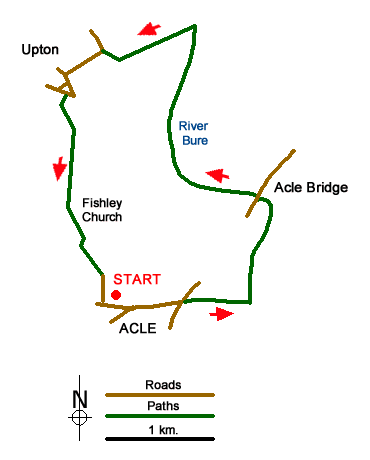
A Norfolk Broads walk that is full of interest including a section of the River Bure, a fine windmill and a lovely round-towered church. The start is the large car park on the north side of Bridewell Lane in the centre of Acle (grid ref. TG401107) which lies to the north of the A47 west of Yarmouth. Exit the car park and turn left along Bridewell Lane. It is easier to stay on the north side of this road. This leads into Old Road which should be followed to a T-junction (the A1064). Bear left here and follow the A1064 for a short way. Cross the road carefully to an open area which gives access to the moorings at Acle Dike.
Walk along the northern side of the Dike (with the Dike to your right) and continue to the River Bure. Turn left here and continue up the river which should be on your right. Continue north to reach the A1064 Acle Bridge (grid ref TG413116). Cross the road with care and continue through the parking area opposite to regain the riverside path. The grassy path continues for a mile and a quarter to reach Upton Dyke (grid ref. TG408130). Shortly before this you pass Clippesby Drainage Mill which provides a fine sight across the River Bure.
Turn left along the south bank of Upton Dyke, which is used for mooring boats and continue out on to Boat Dyke Road (grid ref. TG402127). Follow the road as it bends left and continue to a T-junction ignoring the side roads on your right and left. At the T-junction turn left and continue down to the next road junction with a grass island in the centre of the roads. Turn right here onto “The Green”. After a few yards you will see a footpath sign on your left (grid ref. TG397124). Initially an enclosed path it soon enters a large field. Follow the clear path across this first field. Go through the hedge and then go half left across the next field and then following the same direction across another field to reach a track at a right angled bend (grid ref. TG398114).
On your right is the attractive round towered church of St Mary's, Fishley, which is worth a visit if it is open. To continue take the clear path leaving the track on the bend heading roughly south towards Acle. The path eventually leads into Pyebush Lane which is followed down to a crossroads (grid ref. TG400106). Turn left and the entrance to the car park used at the start of the walk is a short way along Bridewell Lane on your left.
Messaging & Social Media
Message Walking Britain and follow the latest news.

Mountain Weather
Stay safe on the mountains with detailed weather forecasts - for iOS devices or for Android devices.