Dunstable Downs Circular
Chilterns Walk
Region - Chilterns
County/Area - Bedfordshire
Author - Barry Mackie
Length - 4.0 miles / 6.5 km Ascent - 500 feet / 152 metres
Time - 2 hours 30 minutes Grade - easy
Walk Route Description
Click image to visit gallery of 6 images.
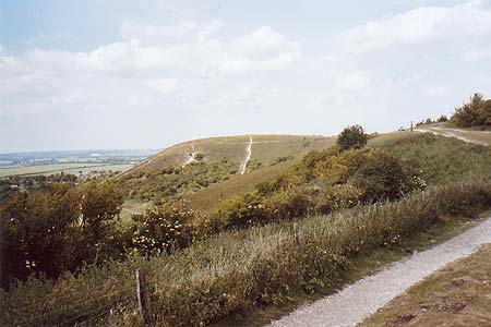
Dunstable Downs lies to the southwest of Dunstable and is part of the Chiltern Hills. These begin in the Thames Valley in Oxfordshire stretching for 40 miles in a North Easterly direction through Buckingham, Bedfordshire, and ending at Hitchin in Hertfordshire. This is a popular place for visitors and has ample free parking. There is also a Visitor Centre where you can buy refreshments.
Turn off the B4541 at the car park adjacent to the Visitor Centre (grid ref TL 008197). Take one of the defined paths next to the Centre and head north for nearly a mile along the top of the grass slope until you reach the Five Knolls. This is the prominent hill at the end of the first section of the walk, which in clear weather is easily visible from the centre.
At the Five Knolls turn west and carefully make your way down the steep slope, until you reach the path, adjacent to the Vale of Aylesbury, at the foot of the Downs. Head south and stay on this path, which gradually veers in a south westerly direction, through open ground and scrubland for approximately 2 miles, until you reach the B4540 (Grid ref. SP 997186) at the foot of Bison Hill.
Turn left on the road, and then left again a few yards later to pick up the bridleway which will lead you up the slope to the top of Bison Hill. At the top of the hill follow the bridleway in a north easterly direction through a large field, scrubland and finally onto open land until you reach your start point at the Visitor Centre.
Maps 

| Ordnance Survey Explorer 181 | Sheet Map | 1:25k | BUY |
| Anquet OS Explorer 181 | Digital Map | 1:25k | BUY |
| Ordnance Survey Explorer 182 | Sheet Map | 1:25k | BUY |
| Anquet OS Explorer 182 | Digital Map | 1:25k | BUY |
| Ordnance Survey Digital Map Subscription | |||
| Latest Ordnance Survey Discounts | |||
Other walks nearby
| Walk 3409 | The Three Counties Tops | mod/hard | 17.0 miles |
| Walk 1833 | Great Gaddesden | easy | 5.2 miles |
| Walk 1999 | The Chilterns above Tring | moderate | 12.0 miles |
| Walk 2399 | The Chilterns above Tring (short version) | easy/mod | 8.0 miles |
| Walk 2064 | Ivinghoe Beacon from the Ashridge Estate | easy/mod | 6.5 miles |
| Walk 1007 | The Ashridge Estate circular | easy/mod | 6.0 miles |
| Walk 3025 | Ashridge Estate Circular | easy | 4.5 miles |
| Walk 2763 | Ivinghoe Beacon Circular | moderate | 8.2 miles |
| Walk 2795 | Circular from Great Gaddesden to Little Gaddessden | easy/mod | 7.5 miles |
| Walk 2999 | Mansions & Parklands from Great Gaddesden | easy/mod | 7.0 miles |
