Moel-y-Gest from Borth-y-Gest
Llyn Peninsula Walk
Region - Llyn Peninsula
County/Area - Gwynedd - Llyn Peninsula
Author - Lou Johnson
Length - 3.8 miles / 6.2 km Ascent - 950 feet / 288 metres
Time - 2 hours 50 minutes Grade - easy/mod
Walk Route Description
Click image to see photo description.
Starting from Borth-y-Gest (Pen Llŷn) this energetic walk explores the twin summits of Moel-y-Gest a rocky hill lying northwest of Porthmadog. The hill offers some scrambling which can easily be avoided if desired. Once on the hill the view includes the Llyn Peninsula Coast, the coast south to Harlech and some of the major mountains in Eryri (Snowdonia).
The walk starts from the car park in Borth-y-Gest opposite the shop and café (grid ref. SH565375). After parking walk along Borth Road with the sea on your right. Continue to reach a footpath sign on a lamp post just before a house name "Issalt" on the left-hand side of the road. Turn left between houses and join a path which leads up to a lane (grid ref. SH562380). Turn right along the lane to reach a main road. Turn right and then first left (with adjacent fingerpost). Continue along the road and pass Tyddyn Llwyn Hotel (on your right). Walk through the car park to reach a marker post which indicates the onward path.
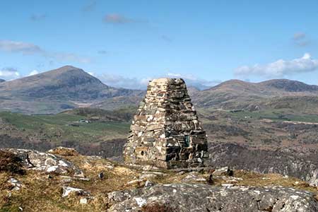
The waymarked path starts to climb, quite steeply in places, soon offering a retrospective view to the coast. Ahead lie the slopes of Moel-y-Gest (Pen Llŷn) with a choice of paths. If in doubt keep heading uphill. A steady climb leads to the east top (231 m.) from where a much better view can be enjoyed. Descend west into a col and start the final climb up to the summit of the west top (263 m.) which was once the site of a hillfort. A concrete OS trig column marks the highest spot. The 360-degree panorama is superb with coast, countryside, and mountains all in view.
To start the descent, take a grassy path on the south side of the ridge. The path leads down to pass through a wall (grid ref. SH551388). Reaching a path junction, keep right and descend to another wall. Pass through the wall and continue half-right across a field, pass through to gaps in walls and then turn right along a path. A steady descent leads down to a more distinct track (grid ref. SH553380) which is followed down to the main road. Cross the road to the pavement opposite and turn left. After 250 metres turn right by a fingerpost and follow the path back to Borth-y-Gest. Reaching the seafront turn right to return to the car park.
Maps 

| Ordnance Survey Explorer 254 | Sheet Map | 1:25k | BUY |
| Anquet OS Explorer 254 | Digital Map | 1:25k | BUY |
| Ordnance Survey Digital Map Subscription | |||
| Latest Ordnance Survey Discounts | |||
Other walks nearby
| Walk 2292 | Moel-y-Gest Porthmadog | easy/mod | 2.5 miles |
| Walk 3370 | Criccieth & Llanstumdwy Circular | easy | 4.5 miles |
| Walk 1173 | Moel Ysgyfarnogod & Foel Penolau | moderate | 6.5 miles |
| Walk 1127 | Cnicht | moderate | 6.3 miles |
| Walk 3035 | The Moelwyns | mod/hard | 7.5 miles |
| Walk 1010 | Cnicht, Moel Druman & Allt-fawr | moderate | 10.0 miles |
| Walk 1422 | Cnicht and Moelwyn Mawr | moderate | 8.0 miles |
| Walk 1191 | Rhinog Fawr & Gloyw Lyn from Cwm Bychan | mod/hard | 5.0 miles |
| Walk 2150 | Llyn Dinas and Cwm Bychan from Beddgelert | easy/mod | 6.0 miles |
| Walk 2560 | Moel Hebog, Moel yr Ogof & Moel Lefn from Beddgelert | mod/hard | 6.5 miles |
Recommended Books & eBooks
Snowdonia: 30 Low-level and easy walks - North
 Guidebook describing 30 walks in Snowdonia, Wales. Routes are mostly low level and on clear paths and showcase the region's beautiful scenery and rich history and culture. Part of a 2-volume set, this northern volume includes the Snowdon area, the Ogwen and Conwy Valleys, Betws-y-Coed, Beddgelert, Ffestiniog and the coast.
More information
Snowdonia: 30 Low-level and easy walks - South
 Guidebook describing 30 walks in Snowdonia, Wales. Routes are mostly low level and on clear paths and showcase the region's beautiful scenery and rich history and culture. Part of a 2-volume set, this southern volume includes Trawsfynydd, Bala, Dolgellau, Machynlleth, the Harlech Coast and the valleys of the Mawddach and Dyfi.
More information
