Walk 2345 - printer friendly version
Clee Hills Walk
Author - Lou Johnson
Length - 6.8 miles / 11 km
Ascent - 700 feet / 212 metres
Grade - easy/mod
Start - OS grid reference SO607872
Lat 52.481299 + Long -2.5801053
Postcode WV16 6TA (approx. location only)
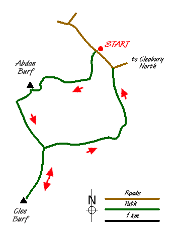
This walk visits the two summits that form the Clee Hills. Abdon Burf, the more northerly of the two is the highest hill in Shropshire. As such it offers some fine views over the surrounding countryside including the Long Mynd. Two kilometres south lies Clee Burf, some 30 metres lower, from where the view south over the rolling landscape of Shropshire is equally good.
The start is the road side parking area alongside the lane at grid ref. SO607872 opposite the signed picnic area. Take the footpath that climbs steeply into the forest. The waymarks direct you uphill with the path crossing over two forestry access tracks to reach a further track at the top of Stanbroughs Woods (Grid ref. SO602865). The character of the woodland changes and the path crosses this track and passes through smaller trees and shrubs to reach a tarmac drive (Grid ref. SO596867) close by some ruined quarry buildings. Turn left along this drive past a pool on your left to arrive at the trig point at 540m. on Shropshire's highest hill. The views north-west and west are the best although by wandering about a little you can get a very good panorama that includes almost the full length of Wenlock Edge. Sadly the summits of Abdon Burf and Clee Burf are littered with radio masts and other modern hilltop 'junk'. However this does not in anyway detract from the view.
From the trig point descend on a clear path south-west. This leads down to the Shropshire Way (Grid ref. SO591862). Turn left and follow the clear path with a fence on your right as it descends to a col between the two hills (Grid ref. SO596853). The easiest way on to Clee Burf is to follow the boundary fence keeping it to your immediate left. There are other paths and these can be confusing and some lead you away from the summit. Reaching the summit, enjoy the view and then retrace your steps back to the col. Turn right down the enclosed bridleway. After 300 metres take the signed path on your right (Grid ref. SO599854). This leads down through open hillside to a bridleway alongside Bridge Pool (Grid ref. SO609855). Turn left along the bridleway keeping straight ahead. After approximately one mile you join a lane (Grid ref. SO610869). Go straight along this lane to reach the start with your transport parked on the right.
Messaging & Social Media
Message Walking Britain and follow the latest news.

Mountain Weather
Stay safe on the mountains with detailed weather forecasts - for iOS devices or for Android devices.